Használati útmutató Navitel Navigator 5.1 PDA
Olvassa el alább 📖 a magyar nyelvű használati útmutatót Navitel Navigator 5.1 PDA (74 oldal) a Navigáció kategóriában. Ezt az útmutatót 9 ember találta hasznosnak és 2 felhasználó értékelte átlagosan 4.5 csillagra
Oldal 1/74

Navigation software
Navitel Navigator
User manual
(For personal digital assistant)
The Join Stock Company "CNT", 2007. All rights reserved.
The contents of this Guide, as well as any attached demo materials, are the sole pro-
prietorship of the Join Stock Company "CNT". Any commercial usage of this Guide may
be carried out only with written permission from the Join Stock Company "CNT". The
information in this document shall not be changed without prior notice given to the Join
Stock Company "CNT".

Contents
1. Introduction................................................................................5
2. General Info ...............................................................................5
3. Technical requirements.................................................................8
4. Navitel Navigator installation..........................................................9
4.1. Software installation................................................................................9
4.1.1. Windows Mobile installation............................................................9
4.1.2. Android installation using DVD........................................................11
4.1.3. Android installation using Market ....................................................13
4.1.4. Symbian OS installation..................................................................15
4.2. Maps and components installation ..........................................................16
4.3. Navitel Navigator registration ..................................................................17
4.3.1. Software online registration ............................................................17
4.3.2 Web registration..............................................................................18
5. Interface....................................................................................20
5.1. “Drive” interface .....................................................................................20
5.2. “Map” interface ......................................................................................22
6. Pages........................................................................................24
6.1. “Map” page ............................................................................................24
6.1.1. Map scrolling .................................................................................24
6.1.2. Zooming ........................................................................................24
6.1.3. Map slope......................................................................................24
6.1.4. GPS-cursor....................................................................................24
6.1.5. Compass .......................................................................................25
6.1.5.1. Map rotation..........................................................................25
6.1.5.2. Map view mode.....................................................................25
6.1.5.3. Day/Night view mode ............................................................25
6.1.6. Information pannel ........................................................................26
6.2. “Dashboard” page ..................................................................................26
6.2.1 Gauges list......................................................................................27
6.3. “Satellites” Page .....................................................................................32
6.4. “Route” Page..........................................................................................33
6.5. “Weather” page ......................................................................................34
7. Main Menu .................................................................................35
7.1. Find........................................................................................................35
7.2. Route .....................................................................................................35
7.2.1. Stop Route Guidance .....................................................................35
7.2.2. Go Next Via Point...........................................................................35
7.2.3. Demo route ...................................................................................36
7.2.4. Show route ....................................................................................36
7.2.5. Route properties ............................................................................36
7.3. Pages.....................................................................................................36
2

3
7.4. Information .............................................................................................37
7.5. Settings..................................................................................................38
7.5.1. Map...............................................................................................38
7.5.1.1. Map ......................................................................................38
7.5.1.2. Detail ....................................................................................39
7.5.1.3. Map rotation..........................................................................40
7.5.1.4. Visual Effects.........................................................................40
7.5.1.5. POI filter................................................................................40
7.5.1.6. Other maps ...........................................................................41
7.5.2. Navigation......................................................................................42
7.5.2.1. Vehicle ..................................................................................42
7.5.2.2. Route ....................................................................................42
7.5.2.3. Zoom settings .......................................................................43
7.5.2.4. Guidance...............................................................................43
7.5.2.5. Lock on road.........................................................................43
7.5.2.6. Reset position .......................................................................43
7.5.3. Regional settings ...........................................................................44
7.5.3.1 Language ...............................................................................44
7.5.3.2 Voice......................................................................................44
7.5.3.3 Keyboard ...............................................................................44
7.5.4. Online services ..............................................................................45
7.5.4.1. Application Update ................................................................45
7.5.4.2. Traffic jams ...........................................................................46
7.5.4.3. Navitel.Events........................................................................46
7.5.4.4. Data Exchange ......................................................................46
7.5.4.5. Weather ................................................................................46
7.5.4.6. Online POI info ......................................................................47
7.5.5. Satellites........................................................................................47
7.5.6. Interface settings ...........................................................................48
7.5.6.1. Skin ......................................................................................48
7.5.6.2. Interface................................................................................49
7.5.6.3. Hide elements .......................................................................50
7.5.6.4. Inertial list scrolling................................................................50
7.5.6.5. Exit confirmation....................................................................50
7.5.7. Device ...........................................................................................50
7.5.7.1. Sound ...................................................................................50
7.5.7.2. Screen orientation .................................................................50
7.5.7.3. Power control ........................................................................51
7.5.7.4. Clock settings .......................................................................51
7.5.7.5. Folders’ settings ....................................................................51
7.5.8. Alerts.............................................................................................51
7.5.9. Track’s setting ...............................................................................52

7.5.9.1. Track record .........................................................................52
7.5.9.2. Track’s format .......................................................................52
7.5.9.3. Track’s folder ........................................................................52
7.5.9.4. Track visualization .................................................................52
7.5.10. Profiles ........................................................................................52
8. Functionality ...............................................................................53
8.1. Routes ...................................................................................................53
8.1.1. Autorouting ....................................................................................53
8.1.2. Autorouting using search................................................................53
8.1.3. Manual route creation ....................................................................54
8.1.4. Route editing .................................................................................54
8.1.5. Edit route waypoints.......................................................................55
8.1.6. Route properties ............................................................................55
8.2. Track......................................................................................................56
8.3. Waypoints...............................................................................................56
8.4. Traffic Jams ...........................................................................................58
8.5. Speed Cameras......................................................................................59
8.6. Search ...................................................................................................60
8.6.1. By Address ....................................................................................60
8.6.2. Nearest places...............................................................................61
8.6.3. “Waypoints” search ........................................................................62
8.6.4. “History” search .............................................................................62
8.6.5. “Favorites” search ..........................................................................63
8.6.6. Search “By coordinates” ...............................................................63
8.6.7. “Navitel.SMS” search .....................................................................63
8.6.8 Crossings search ............................................................................64
8.7. 3D-models..............................................................................................65
8.8. Navitel. SMS .........................................................................................65
8.9. Optional color schemes (Skins)...............................................................65
8.10 Navitel.Events ........................................................................................66
9. Troubleshooting ..........................................................................67
9.1 Problems and solutions............................................................................67
9.2. Running the program after a crash .........................................................69
10. Updating software and maps........................................................70
10.1. Updating Navitel Navigator ....................................................................70
10.2. Updating maps for Navitel Navigator .....................................................70
11. Glossary ..................................................................................71
4

1. Introduction
Navitel Navigator is a navigation software aimed at efficient search of the shortest route
on a map. Voice hints will allow you to navigate the route, not paying attention to the
display, and “Navitel. Traffic Jams” function will help you to overcome any formed traffic
jam on your way.
This document is the user's guide to the navigation program “Navitel Navigator”. It con-
tains full information about the elements of the user interface, the basic functions of the
navigation program, and also the right order of user’s actions in performance of typical
operations.
2. General Info
GPS (Global Positioning System) is a satellite system for high-precision determination
of static and moving objects. To successfully use the navigation software based on GPS
technology, it is necessary to understand some peculiarities of this system.
GPS System also called NAVSTAR (NAVigation System using Timing And Ranging), is
based on the satellites moving around the Earth on orbital trajectories. 24 satellites pro-
vide 100 % serviceability of the system in any point of the globe, but cannot always pro-
vide maximum reception and good calculation of a position. Therefore, for increase of
accuracy of positioning and a reserve in case of failures, the greater numbers of satel-
lites are maintained in orbit it is supported in a lot. The maximal possible number of
simultaneously working satellites in system NAVSTAR is limited to 32.
GPS is a passive system of navigation which allows to receive signals of satellites, how-
ever excludes the possibility of transfering a signal. The signal of GPS satellites has fre-
quencies of 1.227 and 1.575 GHz. It means, that metal and wooden surfaces, some
kinds of plastic, concrete can block electromagnetic wave of such frequency. For this
reason it is impossible to catch satellites in a ferro-concrete building, for this purpose
it is necessary to change the location of the device to a more favourable for the recep-
tion of a signal.
Attention! The most precise results are got when the signal goes into an open area
from at least 4 satellites at one time. Satellites should be uniformly placed in the sky
and the navigator should be fixed.
The quality of position finding depends on that set of satellites which the device cur-
rently works with. If the receiver has an opportunity to choose the best signals from a
variety of accepted, it will have a positive effect on quality of definition of coordinates.
5

If the choice is not possible, accuracy of work will be difficult to predict.
After activating the GPS-receiver the navigating system starts preparing for launch.
Navigating messages transmitted from satellites contain two types of the data —
ephemeris and the almanac of satellites. The almanac contains parameters of an orbit
making possible to calculate an approximate location of the satellites but with rather big
error.
The almanac is stored in memory of the receiver and constantly updates, since each
satellite transfers the data of the almanac for the entire group of satellites. The
almanac's lifetime makes 2-3 months. Further, the size of the integrated error in calcu-
lations will be inadmissible.
Ephemeris data contains parameters which allow to calculate current location of the
satellites more precisely. Unlike the almanac, each of the satellites transfers only it's
own ephemeris. Ephemeris lifetime does not exceed 4-6 hours.
The received information on the ephemeris and the almanac data is constantly correct-
ed. It occurs once a day (and more if necessary). The network of ground stations
receives the information from satellites and analyzes measurements similar to regular
users then compares it with main data followed by adjusting amendments calculation
and transferring them to the main station from which data transmission to satellites is
carried out.
Starting process time necessary for the navigating receiver to define the position after
activation depends on the initial information available in memory. There are several
modes :
• ”Cold start” — time, position, almanac and ephemeris are unknown. The possible
reason is the device being switched off during long time (more than 70 hours) or
his(its) moving in the switched off condition on the big distance. In this case it is
necessary for the device to load the new almanac and ephemeris. This process can
last for more than 20 minutes.
• ”Warm start” — position and ephemeris are unknown, time and the almanac are
known. The device begins data gathering about ephemeris then can carry out a fix-
ing. Usually “Warm start” lasts for some minutes.
• ”Hot start” — the almanac, ephemeris are known, time and a position are known
with some mistakes. This is the fastest kind of system start and it is accessible if
the device was switched off for less than 4 hours. Last data is actual except for
small inaccuracies which the system eliminates in less than a minute.
6

Navitel Navigator is a navigation software developed for personal navigation devices
(PND), pocket PC and PDA working on OS Windows Mobile and equipped with the built-
in or external GPS-receivers.
The Software allows loading detailed maps of cities and regions containing house num-
bers, street names, metro stations and other important information. Among other things,
the satellite navigation software supports voice guidance on a chosen route. The soft-
ware is optimized for small PDA screen resolutions, it has fast map scaling and scroll-
ing, as well as automatic switching between maps having various scales.
Advantages of the Navitel Navigator in comparison with other similar software:
1. Fast map scaling and scrolling;
2. Maps auto switching;
3. Possibility to choose map orientation — on a direction of movement, on a direction
of a route or on a direction to the north;
4. Fullscreen mode;
5. Apart from 2D map viewing mode, there is also the pseudo 3D mode, which sup-
ports three-dimensional image of road overpasses and significant objects of architec-
ture;
6. Pop-up help;
7. Supports traffic jams information upload.
The primary functions of the program are: acquisition and display of current position on
map, automatic and manual route creation, various objects search options, calculation
and display of a plenty of the travelling information, display and record of a trajectory
of movement as a track and many other things.
7
4. Navitel Navigator installation
4.1. Software installation
4.1.1. Windows Mobile installation
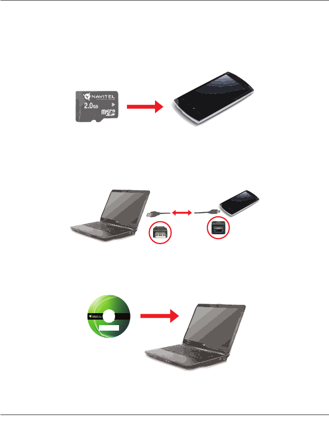
1. Prepare a blank flash card and insert it into the device (Fig. 1) (The flash card may
not be included in a packaging arrangement);
2. Connect the device to a PC using the USB cable (Fig. 2). Please, use the MS
ActiveSync software to synchronize the PC and the device (If you are using Windows
Vista or Windows 7 please use the Mobile Device Center software). You can find the
last version of the software at www.microsoft.com;
3. Insert the Navitel DVD into your PC (Fig. 3) and wait for the autorun to launch. Use
the Exlporer and run the autorun.exe file if the autorun window didn’t appear;
Fig. 1
Fig. 2
Fig. 3
9

4. Select the “Software installation” in the starting screen and press the “Windows
Mobile installation”. You can also use the Exlporer to open the \Install\Navitel
Navigator\WinMobile\NaviTel-setup_PPC-x.x.x.xxx.exe;
5. Next screen holds the list of the system requirements needed to install the software.
Press the “Next” button;
6. Next screen is the license agreement. Please read it and check the “I Agree” item if
you accept all the terms listed. Press “Next” to continue;
7. Select the components which you wish to install on your device. “Navitel Navigator”
is selected by default;
8. The components transfering process will begin;
9. After the components transfering process is finished you will see a message on the
screen. The installation will countinue on the device now;
10. You will be offered to select the install destination: “\Flash Disk” or “\Memory Card”
if your device model supports such. It is recomended to select the “\Memory Card”.
“\Memory Card” can be named differently. For example Storage card or SD-card;
11. The installation process will now begin;
12. Press the “Ok” button after the installation process is finished.
10

4.1.2. Android installation using DVD
1. Go to the “Settings” —> “Applications” menu and check the “Unknown sources” item
(Fig. 4). This will allow to install the Navitel Navigator software on the device;
2. Go to “Settings” — “Location” and check the “GPS satellites” item. This will allow the
usage of GPS satellites for possitioning apart from GSM base stations (Fig. 5)
3. Connect your device to the PC using the USB-cable (Fig. 6);
Fig. 4
Fig. 5
Fig. 6
11

4. Insert the Navitel DVD into your PC DVD-rom (Fig. 7) and wait for the start window
to appear. If the start window didn’t appear, please use the Explorer to run the
autorun.exe file on the DVD (Fig. 19);
5. Select the “Software Installation” in the installation window and select the “Andriod”
item. You can also use the Explorer to launch the Navitel-5.x.x.xxx.exe file in
“\Install\Navitel Navigator\Android\” catalog.
6. Please read the system requirements and press “Next” to copy the installation com-
ponents to the device;
7. The installation process will begin on the device (Fig. 8). Press “Install”;
8. You will see information screen (Fig. 9) after the installation process is finished.
Press an “Open” button to launch the application, or a “Finish” one to close the win-
dow;
Fig. 7
Fig. 8 Fig. 9
12
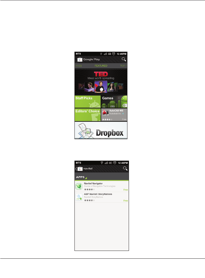
4.1.3. Android installation using Play Store
1. The Internet connection is required for this installation (GPRS, 3G, Wi-Fi or any
other). The installation file size is more than 10Mb so it’s recommended to use a Wi-Fi
connection.
2. Start the “Play Store” application from the device menu. (Fig. 10)
;
3. Press the “Search” button and type “Navitel” in the appeared window. Select the
“Navitel Navigator” item from the found software. (Fig. 11);
Fig. 10
Fig. 11
13

4. The window with an information about the program will appear. (Fig. 12). Learn it and
select the “Install” item;
5. This window (Fig. 13) shows which of the system functions are used by the Navitel
Navigator. Press the “OK”button to continiue;
6. The download and install process will begin. You can control on them in the
“Downloads” menu in the “Market” application (Fig. 14).
Fig. 12
Fig. 13 Fig. 14
14

4.1.4. Symbian OS installation
1. Go to http://navitel.su/download/ and download the installation file for Symbian OS
named “navitel_X.x.x.xxx.sis” (Fig. 15);
2. Copy the “navitel_X.x.x.xxx.sis” to your SD (microSD) card and insert it into your
device (Fig. 16);
3. Open the memory card on your device (“Menu” — “Tools” — “File mgr” — “Memory
Card”) ;
4. Find the “Navitel_X.x.x.xxx.sis”, press “Functions” — “Open”;
5. You will see a notification about the installation. Press “OK”;
6. Choose a place for install. Ensure, that there is more than 15Mb of a free space;
7. Wait for the end of the installation.
Fig. 15
Fig. 16
15

4.2. Maps and components installation
1. Select the “Maps installation” item in the installation screen or use the Exlporer to
open the DVD content;
2. Remove the memory card from the device and use a card-reader device connected
to a PC to access the memory card storage. You can also change the device connec-
tion method so it can be connected to a PC as a card-reader;
3. Copy the “NavitelContent” folder to the root catalog of the SD-card;
Note: “NavitelContent” folder holds:
• License — folder with license files;
• Maps — folder with map files;
• Models — 3D models;
• Tracks — exported routes;
• Skins — optional skins;
• Speedcams — speedcams file (speed bumps, police posts, etc.);
• Voices — optional voice packages.
4. Return the memory card to the device if you used an external card-reader (Fig. 17);
16
Fig. 17

4.3.2 Web registration
1. Please, register at the http://navitel.su/ (Fig. 21);
2. Enter the site using your login and password (Fig. 22);
Fig. 21
Fig. 22
18
Termékspecifikációk
| Márka: | Navitel |
| Kategória: | Navigáció |
| Modell: | Navigator 5.1 PDA |
Szüksége van segítségre?
Ha segítségre van szüksége Navitel Navigator 5.1 PDA, tegyen fel kérdést alább, és más felhasználók válaszolnak Önnek
Útmutatók Navigáció Navitel

22 Augusztus 2024
Útmutatók Navigáció
- Navigáció Grundig
- Navigáció Pioneer
- Navigáció Kia
- Navigáció Garmin
- Navigáció JVC
- Navigáció Volvo
- Navigáció Toyota
- Navigáció Medion
- Navigáció Suzuki
- Navigáció Mazda
- Navigáció Skoda
- Navigáció Kenwood
- Navigáció Audi
- Navigáció Seat
- Navigáció Raymarine
- Navigáció Parrot
- Navigáció Tacx
- Navigáció Sygic
- Navigáció Prestigio
- Navigáció Mio
- Navigáció TomTom
- Navigáció Mappy
- Navigáció GlobalTronics
- Navigáció Zenec
- Navigáció GoClever
- Navigáció Packard Bell
- Navigáció A-Rival
- Navigáció Apelco
- Navigáció LX NAV
- Navigáció Marquant
- Navigáció Binatone
- Navigáció Magellan
- Navigáció TakeMS
- Navigáció Audiovox
- Navigáció Navigon
- Navigáció Eagle
- Navigáció Targa
- Navigáció Hagenuk
- Navigáció Autovision
- Navigáció Navman
- Navigáció Sungoo
- Navigáció Simrad
- Navigáció Danew
- Navigáció Snooper
- Navigáció VDO Dayton
- Navigáció Macrom
- Navigáció Becker
- Navigáció Fujitsu Siemens
- Navigáció Igo
- Navigáció Bluetech
- Navigáció Route 66
- Navigáció Falk
- Navigáció Seecode
- Navigáció Nav N Go
- Navigáció Bullit
- Navigáció Viamichelin
- Navigáció Xzent
- Navigáció Navteq
- Navigáció Igo 8
- Navigáció Keomo
- Navigáció RoHS
- Navigáció Invion
- Navigáció VW
- Navigáció Raystar
- Navigáció Eclipse
- Navigáció Holux
- Navigáció PENTAGRAM
- Navigáció Roadnavigator
- Navigáció WayteQ
- Navigáció GoRider
Legújabb útmutatók Navigáció
15 Január 2025
12 Január 2025
5 Október 2024
5 Október 2024
5 Október 2024
5 Október 2024
5 Október 2024
5 Október 2024
23 Szeptember 2024
21 Szeptember 2024