Használati útmutató Igo Primo Navigation - Macrom Mobile Multimedia
Olvassa el alább 📖 a magyar nyelvű használati útmutatót Igo Primo Navigation - Macrom Mobile Multimedia (81 oldal) a Szoftver kategóriában. Ezt az útmutatót 13 ember találta hasznosnak és 2 felhasználó értékelte átlagosan 4.5 csillagra
Oldal 1/81
User Manual
iGO primo
Navigation software for the Macrom Mobile Multimedia
UK English
Mayl 2011, ver. 1.2.1
2
Thank you for choosing the Macrom Mobile Multimedia as your navigator. Start using your
device right away. This document is the detailed description of the navigation software. You
can easily discover iGO primo while you are using it; however, we still recommend that you
read this manual to fully understand the screens and features.
3
Table of contents
1 Warnings and Safety information.......................................................... 6
2 Getting started.......................................................................................... 7
2.1 Navigation menu.............................................................................................8
2.2 Buttons and other controls on the screen........................................................8
2.2.1 Using keyboards ................................................................................................10
2.2.2 Beyond single screen tap ...................................................................................11
2.3 Map screen....................................................................................................11
2.3.1 Navigating on the map.......................................................................................11
2.3.2 Position markers ................................................................................................13
2.3.2.1 Vehimarker and Lock-on-Road................................................................................13
2.3.2.2 Selected map location (Cursor) and selected map object ........................................13
2.3.3 Objects on the map ............................................................................................14
2.3.3.1 Streets and roads .....................................................................................................14
2.3.3.2 Turn preview and Next street...................................................................................14
2.3.3.3 Lane information and Signposts...............................................................................15
2.3.3.4 Junction view...........................................................................................................16
2.3.3.5 Motorway exit services ............................................................................................16
2.3.3.6 3D object types.........................................................................................................17
2.3.3.7 Elements of the active route.....................................................................................17
2.3.3.8 Traffic events ...........................................................................................................17
2.3.4 Manipulating the map........................................................................................18
2.3.5 Quick menu........................................................................................................20
2.3.6 Checking the details of the current position (Where Am I?) .............................22
3 On-road navigation................................................................................ 24
3.1 Selecting the destination of a route...............................................................24
3.1.1 Entering an address or a part of the address.......................................................24
3.1.1.1 Entering an address.................................................................................................25
3.1.1.2 Entering the midpoint of a street as the destination.................................................27
3.1.1.3 Selecting an intersection as the destination.............................................................28
3.1.1.4 Selecting a city/town centre as the destination.........................................................30
3.1.1.5 Entering an address with a postal code...................................................................31
3.1.1.6 Tips on entering addresses quickly..........................................................................33
3.1.2 Selecting the destination from the Places of Interest .........................................33
3.1.2.1 Quick search for a Place of Interest.........................................................................34
3.1.2.2 Searching for a Place of Interest using preset categories........................................35
3.1.2.3 Searching for a Place of Interest by category..........................................................37
3.1.2.4 Searching for a Place of Interest by name...............................................................39
3.1.2.5 Selecting nearby assistance from 'Where Am I?' .....................................................42
3.1.3 Selecting a map location as the destination .......................................................43
3.1.4 Selecting the destination from your Favourites .................................................44
4
3.1.5 Selecting one of the most likely destinations (Smart History)...........................45
3.1.6 Selecting a recent destination from the History.................................................46
3.1.7 Entering the coordinate of the destination .........................................................47
3.1.8 Building a route from the list of destinations (Create Route) ............................48
3.2 Viewing the entire route on the map.............................................................49
3.3 Checking route parameters and accessing route related functions..............49
3.4 Modifying the route.......................................................................................50
3.4.1 Selecting a new destination when already having a route: New Route, Waypoint or Final
Destination....................................................................................................................50
3.4.2 Setting a new starting position for the route ......................................................51
3.4.3 Editing the list of destinations (Edit Route).......................................................52
3.4.4 Pausing the active route.....................................................................................53
3.4.5 Cancelling the active route ................................................................................53
3.4.6 Checking route alternatives when planning the route........................................53
3.4.7 Checking route alternatives for an existing route ..............................................54
3.4.8 Changing the vehicle used in route planning.....................................................56
3.4.9 Changing the road types used in route planning................................................56
3.5 Saving a location as a Favourite destination................................................57
3.6 Saving a location as an alert point ...............................................................58
3.7 Editing an alert point....................................................................................59
3.8 Watching the simulation of the route............................................................59
4 Off-road navigation................................................................................ 61
4.1 Selecting the destination of the route............................................................61
4.2 Navigating in off-road mode.........................................................................61
5 Reference Guide..................................................................................... 62
5.1 Concepts........................................................................................................62
5.1.1 Smart Zoom.......................................................................................................62
5.1.2 Daytime and night colour themes ......................................................................62
5.1.3 Route calculation and recalculation...................................................................62
5.1.4 Green routing.....................................................................................................64
5.1.5 Speed limit warning...........................................................................................65
5.1.6 GPS position quality indicators .........................................................................65
5.1.7 Traffic information in route planning ................................................................66
5.1.7.1 Real-time traffic information (TMC)........................................................................66
5.2 'More' menu...................................................................................................68
5.3 Settings menu................................................................................................69
5.3.1 Sound and Warnings..........................................................................................70
5.3.2 Customise Quick menu......................................................................................71
5.3.3 Traffic settings...................................................................................................72
5.3.4 Route settings.....................................................................................................72
5.3.5 Map settings.......................................................................................................76
5
5.3.6 Visual guidance settings ....................................................................................77
5.3.7 Display settings..................................................................................................78
5.3.8 Regional settings................................................................................................78
5.3.9 Trip monitor settings..........................................................................................78
6 Glossary................................................................................................... 79
7 Copyright note........................................................................................ 81
6
1 Warnings and Safety information
The navigation system helps you find your way to your destination with the built-in GPS
receiver. iGO primo does not transmit your GPS position; others cannot track you.
It is important that you look at the display only when it is safe to do so. If you are the driver of
the vehicle, we recommend that you operate iGO primo before you start your journey. Plan
the route before your departure and stop if you need to change the route.
You must obey the traffic signs and follow the road geometry. If you deviate from the
recommended route, iGO primo changes the instructions accordingly.
Never place your device where it obstructs the driver's view, where it is in the deployment
zone of an airbag or where it might cause injuries in an accident.

7
2 Getting started
iGO primo is optimised for in-car or pedestrian use. There is no need to use a stylus. You can
use it easily by tapping the screen buttons and the map with your fingertips.
When using the navigation software for the first time, an initial setup process starts
automatically. Do as follows:
1. The language of the application is taken from the language settings of your device.
You do not need to select the language.
2. Read the End User Licence Agreement. Tap to continue.
3. The Configuration wizard starts. Tap to continue.
4. Select the language and speaker used for voice guidance messages. Later you can
change it in Sound and Warnings settings (page 71).
5. If needed, modify the time format and unit settings. Later you can change them in
Regional settings (page 78).
6. If needed, modify the default route planning options. Later you can change them in
Route settings (page 72).
7. The initial setup is now complete. The Configuration wizard can be restarted later from
the Settings menu (page 69).
After the initial setup, the Navigation menu appears and you can start using iGO primo.

8
2.1 Navigation menu
You can reach all parts of iGO primo from the Navigation menu.
You have the following options:
Tap to select your destination by entering an address or selecting
a place of interest, a location on the map or one of your Favourite destinations. You
can also look up your recent destinations from the Smart History or enter a coordinate.
Tap to display the route parameters and the route in its full length
on the map. You can also perform route-related actions such as editing or cancelling
your route, setting a start point for the route, picking route alternatives, avoiding parts
of the route, simulating navigation or adding the destination to your Favourites.
Tap to customise the way the navigation software works, to
simulate demo routes or to run some additional applications.
Tap to start navigating on the map. The button itself is a miniature
live map that shows your current position, the recommended route and the surrounding
map area. Tap the button to enlarge the map to the full screen.
Tap to open the Traffic Summary screen.
Tap to stop navigation and exit the software.
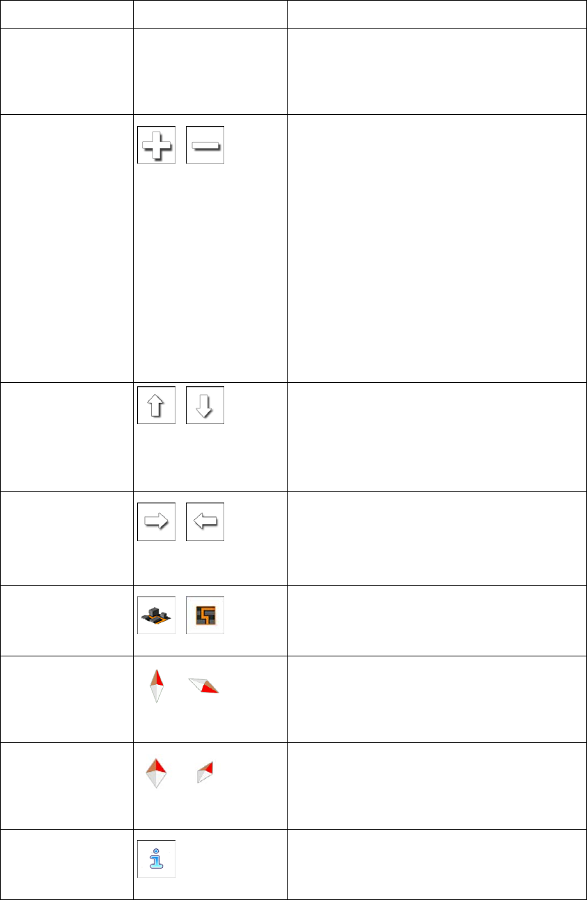
2.2 Buttons and other controls on the screen
When you are using iGO primo, you usually tap buttons on the touch screen.
You only need to confirm selections or changes if the application needs to restart, it needs to
perform a major reconfiguration, or you are about to lose some of your data or settings.
Otherwise, iGO primo saves your selections and applies the new settings without confirmation
as soon as you use the controls.
Type Example Description How to use it
Button
Tap it to initiate a function,
to open a new screen, or
to set a parameter.
Tap it once.
9
Button
with
value
Some buttons display the
current value of a field or
setting. Tap the button to
change the value. After the
change, the new value is
shown on the button.
Tap it once.
Icon
Shows status information. Some icons also
function as a button.
Tap them once.
List
When you need to select
from several options, they
appear in a list.
Grab the list anywhere
and slide your finger up
or down. Depending on
the speed of the sliding,
the list will scroll fast or
slow, only a bit or till the
end.
Alternatively, move
between pages with the
and
buttons and tap the
value that you want.
Radio
button
When there are only a few
choices, radio buttons may
be used instead of lists.
Only one value can be
selected.
Tap one of the buttons
to select a new value.
Switch
When there are only two
choices, a checkmark
shows whether the feature
is enabled.
Tap it to turn the switch
on or off.
Slider
When a feature can be set
to different values in a
range, iGO primo shows
an indicator on a gauge
that displays and sets the
value.
Drag the handle
to move the
slider to its new
position.
Tap the slider
where you want
the handle to
appear; the
thumb jumps
there.
Virtual
keyboard
Alphabetic and
alphanumeric keyboards to
enter text and numbers.
Each key is a touch
screen button.

10
2.2.1 Using keyboards
You only need to enter letters or numbers when you cannot avoid it. You can type with your
fingertips on the full-screen keyboards and you can switch between various keyboard layouts,
for example English, Greek or numerical.
Task Instruction
Switching to another keyboard layout, for
example from an English keyboard to a
Greek keyboard Tap the button and select
the new keyboard layout from the list.
Correcting your entry on the keyboard
Tap to remove the unneeded character(s).
Tap and hold the button to delete several
characters or the entire input string.
Entering a space, for example between a
first name and a family name or in multi-
word street names Tap the button at the bottom centre of the
screen.
Entering numbers and symbols
Tap to switch to a keyboard offering
numeric and symbol characters.
Finalising the keyboard entry (accepting
the suggested search result) Tap .
Finalising the keyboard entry (opening the
list of search results) Tap .
Finalising the keyboard entry (saving your
input) Tap .
Cancelling the keyboard entry (returning
to the previous screen) Tap .

11
2.2.2 Beyond single screen tap
You usually need to tap the screen only once. However, some useful features can be
accessed with combined touch screen tapping. Those are the following:
Action Details
Tapping and holding
the screen Tap and keep pressing the following buttons to reach extra functions:
Tap and hold on list and menu screens:
the Map screen appears.
Tap and hold any of the , , , , ,
and buttons on the Map screen: you can rotate, tilt or
scale the map continuously.
Tap and hold on keyboard screens: you can delete
several characters quickly.
Tap and hold or in long lists: you can scroll pages
continuously.
Gestures
(drag&drop) You need to drag and drop the screen only in cases like:
Moving the handle on a slider.
Scrolling the list: grab the list anywhere and slide your finger up
or down. Depending on the speed of the sliding, the list will
scroll fast or slow, only a bit or till the end.
Moving the map in map browsing mode: grab the map, and
move it in the desired direction.
2.3 Map screen
2.3.1 Navigating on the map
The Map screen is the most frequently used screen of iGO primo.
A small live map is displayed on the Navigation menu, as a part of the
button.
12
To enlarge this small map and open the Map screen, tap .
This map shows the current position (the Vehimarker, a blue arrow by default), the
recommended route (an orange line), and the surrounding map area.
When there is no GPS position, the Vehimarker is transparent. It shows your last known
position.
You see coloured dots circling around a satellite symbol in the top left corner. The more green
dots you see, the closer you are to get the valid GPS position.
When GPS position is available, the Vehimarker is displayed in full colour, now showing your
current position.
There are screen buttons and data fields on the screen to help you navigate. During
navigation, the screen shows route information.
By default, only one data field is displayed in the bottom right corner. Tap this field to see all
route data fields.
Tap any of the data fields to suppress others and display only the selected one. The data
fields are different when you are navigating an active route and when you have no specified
destination (the orange line is not displayed).
Default data fields when cruising without a destination (tap and hold any of the fields to
change its value):
Field Description
Shows your current speed given by the GPS receiver.
Shows the speed limit of the current road if the map contains it.
13
Shows the current time corrected with time zone offset. The accurate
time comes from the GPS satellites, and the time zone information
comes from the map or it can be set manually in Regional settings.
(The current time is always displayed in the top left corner of menu
screens.)
Default data fields when navigating a route (tap and hold any of the fields to change its value):
Field Description
Shows the distance you need to travel on the route before reaching
your final destination.
Shows the time needed to reach the final destination of the route
based on information available for the remaining segments of the
route.
If your device is capable of receiving live traffic information, the
calculation takes into account traffic delays affecting your route if they
are received. However, this calculation is rarely accurate.
Shows the estimated arrival time at the final destination of the route
based on information available for the remaining segments of the
route.
If your device is capable of receiving live traffic information, the
calculation takes into account traffic delays affecting your route if they
are received. However, this calculation is rarely accurate.
2.3.2 Position markers
2.3.2.1 Vehimarker and Lock-on-Road
When your GPS position is available, iGO primo marks your current position with the
Vehimarker. By default, this marker is a blue arrow, but you can change this icon in Settings.
The exact location of the Vehimarker depends on the vehicle type used for route calculation
and the navigation mode. Both can be set in Route settings (page 72).
If you choose pedestrian and/or off-road navigation: The Vehimarker is at your exact
GPS position. The direction of the icon shows your current heading.
In all other cases: The Vehimarker may not show your exact GPS position and
heading. If roads are near, it is aligned to the nearest road to suppress GPS position
errors, and the direction of the icon is aligned to the direction of the road.
2.3.2.2 Selected map location (Cursor) and selected map object
You can mark a map location in the following ways:
Tap the map when navigating,
Tap the map when you are asked to confirm the destination at the end of a search, or
14
Tap the map in Find on Map (page 43)
When a map location is selected, the Cursor appears at the selected point on the map. The
Cursor is displayed with a radiating red dot ( ) to make it visible at all zoom levels.
The location of the Cursor can be used as the destination of the route, a new alert point, you
can search for Places around it, or you can save this location as one of your Favourite
destinations.
You can also select some of the objects on the map. If you tap the map at the icon of a Place
of Interest or an alert point, the object will be selected (you see a red circling border around
the object), and you can get information about this object or use it as a route point.
2.3.3 Objects on the map
2.3.3.1 Streets and roads
iGO primo shows the streets in a way that is similar to how the paper road maps show them.
Their width and colours correspond to their importance: you can easily tell a motorway from a
small street.
2.3.3.2 Turn preview and Next street
When navigating a route, the top section of the Map screen shows information about the next
route event (manoeuvre) and the next street or the next city/town.
There is a field in the top left corner that displays the next manoeuvre. Both the type of the
event (turn, roundabout, exiting motorway, etc.) and its distance from the current position are
displayed.
A smaller icon shows the type of the second next manoeuvre if it is near the first one.
Otherwise, only the next manoeuvre is displayed.
Most of these icons are very intuitive. The following table lists some of the frequently shown
route events. The same symbols are used in both fields:
Icon Description
Turn left.

15
Turn right.
Turn back.
Bear right.
Turn sharp left.
Keep left.
Continue straight in the intersection.
Go left on the roundabout, 3rd exit (next
manoeuvre).
Enter roundabout (second next manoeuvre).
Enter motorway.
Exit motorway.
Board ferry.
Leave ferry.
Approaching a waypoint.
Approaching the destination.
2.3.3.3 Lane information and Signposts
When navigating on multilane roads, it is important to take the appropriate lane in order to
follow the recommended route. If lane information is available in the map data, iGO primo
displays the lanes and their directions using small arrows at the bottom of the map.
Highlighted arrows represent the lanes you need to take.
Where additional information is available, signposts substitute arrows. Signposts are
displayed at the top of the map. The colour and style of the signposts are similar to the real
ones you can see above road or by the roadside. They show the available destinations and
the number of the road the lane leads to.
All signposts look similar when cruising (when there is no recommended route). When
navigating a route, only the signpost that points to the lane(s) to be taken is displayed in vivid
colours; all others are darker.
If you want to hide the currently displayed signposts, tap any of them and the normal Map
screen returns until new signpost information is received.

16
2.3.3.4 Junction view
If you are approaching a motorway exit or a complex intersection and the needed information
exists, the map is replaced with a 3D view of the junction. The lanes you need to take are
displayed with arrows. Signposts can also be present if information is available.
If you want to hide the currently displayed junction, tap the picture and the Map screen
returns.
2.3.3.5 Motorway exit services
You may need a petrol station or a restaurant during your journey. This feature displays a
new button on the map when you are driving on motorways.
Tap this button to open a panel with the details of the next few exits or service stations.
Tap any of them to display it on the map and add it as a waypoint to your route if needed.
If you want to display other types of Places for the exits, you can change the icons in Visual
Guidance settings (page 77).

17
2.3.3.6 3D object types
iGO primo supports the following 3D object types:
Type Description
3D terrain 3D terrain map data shows changes in terrain, elevations or depressions in
the land when you view the map in 2D, and use it to plot the route map in
3D when you navigate. Hills and mountains are shown in the background of
the 3D map, and illustrated by colour and shading on the 2D map.
Elevated roads Complex intersections and vertically isolated roads (such as overpasses or
bridges) are displayed in 3D.
2.3.3.7 Elements of the active route
iGO primo shows the route in the following way:
Symbol Name Description
Current GPS position and
Start point Your current position displayed on the map.
In pedestrian mode it is the exact GPS
position.
If a vehicle is selected for route calculation
and roads are near, the symbol is snapped
onto the nearest road.
Normally if GPS position is available, the route
starts from the current position. If there is no valid
GPS position, iGO primo uses the last known
position as the start point.
Waypoint (intermediate
destination) An intermediate destination of the route before
reaching the final destination.
Destination (end point) The final destination of the route.
Route colour The route always stands out with its colour on the
map, both in daytime and in night colour mode.
Streets and roads that are
excluded from the navigation You can choose whether you want to use or
avoid certain road types (page 72). However,
when iGO primo cannot avoid such roads, the
route will include them and it will show them in a
colour that is different from the route colour.
Streets and roads that are
affected by traffic events Road segments may be affected by traffic events
received. These streets and roads are displayed
in an alternate colour, and small symbols
displayed along the route show the type of the
traffic event.
2.3.3.8 Traffic events
Road segments affected by traffic events are displayed with an alternate colour on the map,
and small symbols above the road show the nature of the event:

18
Tap to open the Traffic Summary screen.
Tap to open the list of traffic events:
Now tap any of the list items to see its details, and to display the affected road segment in its
full length on the map:
Note! If there are traffic events on the recommended route that the application has no
t
bypassed, the icon will open the list of significant traffic events to let you
quickly check them.
2.3.4 Manipulating the map
Tap the map anywhere to browse it during navigation. The map stops following the current
position (the Vehimarker, a blue arrow by default, is not locked in a fix position on the screen
any more) and control buttons appear to help you modify the map view.
19
Action Button(s) Description
Moving the map
with drag&drop No buttons You can move the map in any direction: tap
and hold the map, and move your finger
towards the direction you want to move the
map.
Zooming in and out
,
Changes how much of the map is displayed on
the screen.
iGO primo uses high-quality vector maps that
let you examine the map at various zoom
levels, always with optimised content. It always
displays street names and other text with the
same font size, never upside-down, and you
only see the streets and objects that you need.
Map scaling has a limit in 3D map view mode.
If you zoom out further, the map switches to
2D view mode.
Tap the button once to modify the view in large
steps, or tap and hold the button to modify it
continuously and smoothly.
Tilting up and down
, Changes the vertical view angle of the map in
3D mode.
Tap the button once to modify the view in large
steps, or tap and hold the button to modify it
continuously and smoothly.
Rotating left and
right ,
Changes the horizontal view angle of the map.
Tap the button once to modify the view in large
steps, or tap and hold the button to modify it
continuously and smoothly.
2D or 3D view
,
Tap this button to switch between the 3D
perspective and 2D top-down map view
modes.
Compass in 2D
map view mode ,
The direction of the compass shows North.
Tap the button to switch to North-up view, and
then tap again to rotate the map in the
previous direction.
Compass in 3D
map view mode ,
The direction of the compass shows North.
Tap the button to switch to North-up view, and
then tap again to rotate the map in the
previous direction.
Location
information
Tap this button to open a new screen with
information about the selected map point, the
Cursor.

20
Return to normal
navigation Tap this button to move the map back to follow
the current GPS position. Automatic map
rotation is also re-enabled.
The map manipulation buttons disappear and
navigation continues.
Additional options
Tap this button to open a list of additional
features like saving the Cursor as a Favourite
destination, or searching for Places around the
Cursor.
Select destination
Tap this button to select the Cursor as a new
destination. The route is automatically
calculated.
2.3.5 Quick menu
The Quick menu is a selection of controls and functions that are frequently needed during
navigation. It can be opened directly from the Map screen by tapping .
The menu will close after a few seconds of inactivity or if you tap .
The menu will also close if you initiate simple controls like muting the device. In other cases
tapping a button will open a new screen with options.
Most of these functions are shortcuts. They are accessible from the menu system.
There are more functions available than the number of buttons in the menu. In Settings, you
can choose the function of each button (page 71). The following options are available:
Button Description Shortcut for
Master Volume
slider This slider adjusts the sound volume of the device.
All sounds of the application are affected. More / Settings /
Sound and Warnings
/
Volume / Master
slider
,
This switch mutes all sounds of the device. Tap again
to re-enable sounds. More / Settings /
Sound and Warnings
/ Volume / Master
switch
This function lets you search for a Place along your
route or around your current location if there is no
route calculated.
Find / Find Places /
Quick Search (page
34)

21
This button opens the list of your Favourite
destinations. Find / Favourite (page
44)
This button opens the History list. You can select one
of your previous destinations. Find / History (page
46)
This button opens the route editing function. My Route / Edit Route
This button opens the route related settings. More / Settings /
Route Settings (page
72)
This button opens the map related settings. More / Settings / Map
Settings (page 76)
This button opens a special screen with information
about the current position and a button to search for
nearby emergency or roadside assistance. For
details, see the next chapter.
Tap the Current
Street field on the
Map screen
This button cancels the route and stops navigation.
The button is replaced with the next one if waypoints
are given.
My Route / Cancel
Route (page 53)
This button skips the next waypoint from the route. n/a
This button opens a 2D map scaled and positioned to
show the entire route. My Route / Overview
(page 49)
This button opens the Visual Guidance settings
screen. More / Settings /
Visual Guidance
(page 77)
This button opens the Traffic Summary screen. Tap the Traffic icon in
the Navigation menu
or on the Map screen
This button lets you bypass parts of the
recommended route. My Route /
Avoidances

22
This button opens the Trip Monitor screen where you
can manage your previously saved trip logs and track
logs.
More / Trip Monitor
(page 68)
This button opens the list of manoeuvres (the
itinerary). Tap the top of the
Map screen during
navigation.
With this function you can save the active route for
later use. My Route / More /
Save Route
With this function you can replace the active route
with a previously saved route. My Route / More /
Load Route
With this function you can search for Places of
Interest in various different ways. Find / Find Places
(page 33)
This button opens the Map screen and starts
simulating the active route. My Route / More /
Simulate Navigation
(page 59)
This button opens the GPS Information screen with
satellite position and signal strength information. Tap the top of the
Map screen when
there is no GPS
reception
This button opens the parameters of the selected
Vehicle profile. More / Settings /
Route (page 72)
2.3.6 Checking the details of the current position (Where Am I?)
This screen contains information about the current position (or about the last known position if
GPS reception is not available) and a button to search for useful Places nearby.
.
You can access this screen from the map in one of the following ways:
If the current street is displayed below the Vehimarker (the current position on the
map), tap it to open the Where Am I? screen.
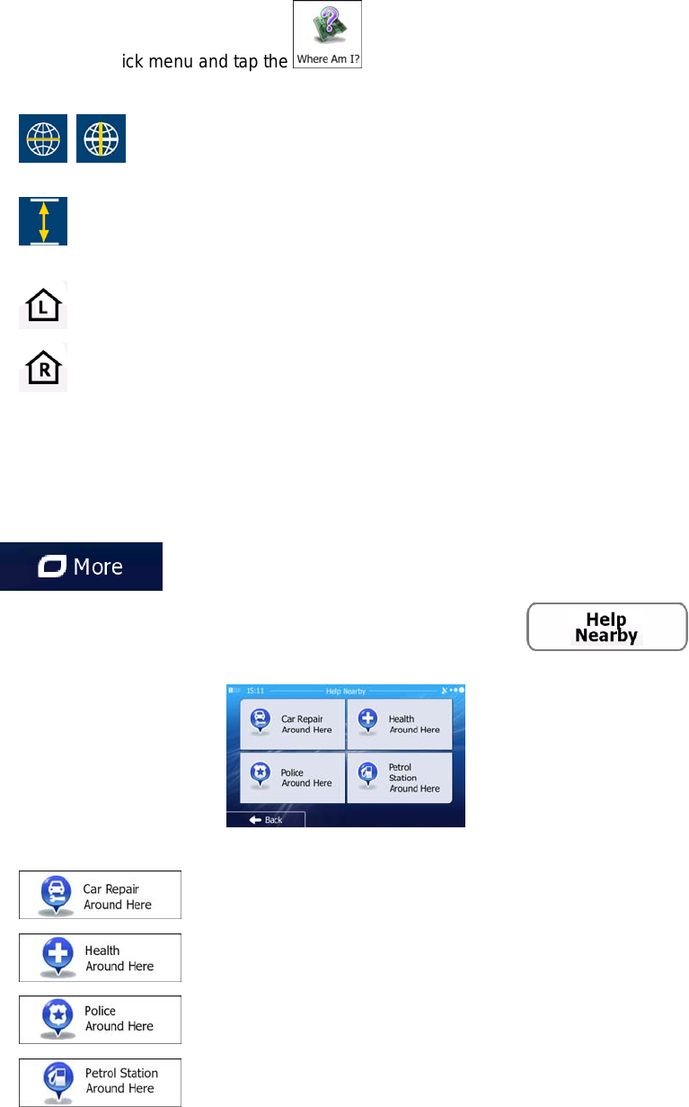
23
Open the Quick menu and tap the button.
Information on this screen:
, : Latitude and Longitude (coordinate of the current position in WGS84
format).
: Altitude (elevation information coming from the GPS receiver - often
inaccurate).
: House number on the left.
: House number on the right.
In the middle of the screen you can see whether the position is current, or the time left
since it was last updated.
Address details (when available) of the current position are also displayed at the
bottom.
You can also perform some actions on this screen:
Tap to save the current position as a Favourite destination.
You can also search for assistance near your current position. Tap to
open a new screen for the Quick search:
The following services can be searched around the current position or the last known position:
: Car repair and roadside assistance services
: Medical and emergency services
: Police stations
: Petrol stations
Tap any of the buttons, select a Place from the list, and navigate to it.
24
3 On-road navigation
When first started, iGO primo calculates routes using the road network of the high quality
vector maps provided with the product.
You can set up your route in different ways:
If you need a route for immediate navigation, you can select the destination and start
navigating to it right away (normal navigation).
You can also plan a route independently of your current GPS position or even without
GPS reception (to achieve this, you need to turn off the GPS receiver and set a new
starting point in My Route / Edit Route by tapping the flag icon at the current position).
You can plan routes with multiple destinations. Select the first destination. Then select a
second destination and add it to your route to create a multi-point route. You can add as
many destinations to your route as you like.
You can also use iGO primo for off-road navigation. For details, see page 61.
3.1 Selecting the destination of a route
iGO primo offers you several ways of choosing your destination:
Enter a full address or a part of an address, for example a street name without a house
number or the names of two intersecting streets (page 24).
Enter an address with postal code (page 31). This way you do not need to select the
name of the city/town and the search for street names might be faster as well.
Use a built-in Place of Interest as your destination (page 33).
Select a location on the map with the Find on Map feature (page 43).
Use a previously saved Favourite destination (page 44).
Select a location from the History of previously used destinations (page 46).
Enter the coordinate of the destination (page 47).
3.1.1 Entering an address or a part of the address
If you know at least a part of the address, it is the quickest way to select the destination of the
route.
Using the same screen, you can find an address by entering:
the exact address, including house number
the centre of a city/town
an intersection
the midpoint of a street
any of the above, starting the search with the postal code (page 31)
25
3.1.1.1 Entering an address
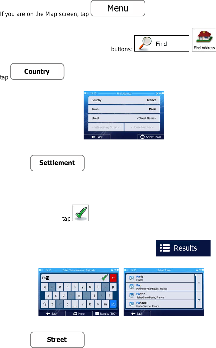
To enter an address as the destination, do as follows:
1. If you are on the Map screen, tap to return to the Navigation
menu.
2. In the Navigation menu, tap the following buttons: , .
3. By default, iGO primo proposes the country and city/town where you are. If needed,
tap , enter the first few letters of the country name on the
keyboard, and select one country from the list of results.
4. If needed, select a new city/town:
a. Tap .
b. Start entering the name of the city/town on the keyboard.
c. Find the city/town you need:
The most likely city/town name is always shown in the input field. To
accept it, tap .
If the desired name does not show up, the names that match the string
appear in a list after entering a couple of characters (to open the list of
results before it appears automatically, tap ). Select
the city/town from the list.
5. Enter the street name:
a. Tap .
b. Start entering the street name on the keyboard.
c. Find the street you need:
26
The most likely street name is always shown in the input field. To accept
it, tap .
If the desired name does not show up, the names that match the string
appear in a list after entering a couple of characters (to open the list of
results before it appears automatically, tap ). Select
the street from the list.
6. Enter the house number:
a. Tap .
b. Enter the house number on the keyboard. (To enter letters, tap ).
c. Tap to finish entering the address. (If the entered house
number cannot be found, the midpoint of the street is selected as the
destination.)
7. A full screen map appears with the selected point in the middle. If necessary, tap the
map somewhere else to modify the destination. The Cursor ( ) appears at the
new location. Tap to confirm the destination, or tap
to select a different destination.
8. After a short summary of the route parameters, the map appears showing the entire
route. The route is automatically calculated. Tap to modify route
parameters, or tap and start your journey.

27
Tip! If you know that you will use this destination frequently, before tapping
to confirm the destination, put it on the list of you
r
Favourites first: tap then , give a
name for the new Favourite, and tap to save the location.
The map with the destination returns automatically. Now you can start you
r
journey.
3.1.1.2 Entering the midpoint of a street as the destination
You can navigate to the midpoint of a street if the house number is not available:
1. If you are on the Map screen, tap to return to the Navigation
menu.
2. In the Navigation menu, tap the following buttons: , .
3. If necessary, modify the country and city/town as described earlier (page 25).
4. Enter the street name:
a. Tap .
b. Start entering the street name on the keyboard.
c. Find the street you need:
The most likely street name is always shown in the input field. To accept
it, tap .
If the desired name does not show up, the names that match the string
appear in a list after entering a couple of characters (to open the list of
results before it appears automatically, tap ). Select
the street from the list.

28
5. Instead of entering the house number, tap . The midpoint of the
street is selected as the destination.
6. A full screen map appears with the selected point in the middle. If necessary, tap the
map somewhere else to modify the destination. The Cursor ( ) appears at the
new location. Tap to confirm the destination, or tap
to select a different destination.
7. After a short summary of the route parameters, the map appears showing the entire
route. The route is automatically calculated. Tap to modify route
parameters, or tap and start your journey.
3.1.1.3 Selecting an intersection as the destination
To enter an address as the destination, do as follows:
1. If you are on the Map screen, tap to return to the Navigation
menu.
2. In the Navigation menu, tap the following buttons: , .
3. If necessary, modify the country and city/town as described earlier (page 25).
4. Enter the street name:
a. Tap .
b. Start entering the street name on the keyboard.
c. Find the street you need:
The most likely street name is always shown in the input field. To accept
it, tap .

29
If the desired name does not show up, the names that match the string
appear in a list after entering a couple of characters (to open the list of
results before it appears automatically, tap ). Select
the street from the list.
5. Enter the intersecting street name:
1. Tap .
If only a few intersecting streets exist, their list appears immediately.
In case of a longer street, the keyboard screen appears. Start entering
the name of the intersecting street on the keyboard. As soon as the street
names that match the entered string can be shown on one screen, their
list appears automatically. Select from the list.
6. A full screen map appears with the selected point in the middle. If necessary, tap the
map somewhere else to modify the destination. The Cursor ( ) appears at the
new location. Tap to confirm the destination, or tap
to select a different destination.
7. After a short summary of the route parameters, the map appears showing the entire
route. The route is automatically calculated. Tap to modify route
parameters, or tap and start your journey.

30
3.1.1.4 Selecting a city/town centre as the destination
The city/town centre is not the geometric centre of the city/town but an arbitrary point the map
creators have chosen. In towns and villages, it is usually the most important intersection; in
larger cities, it is one of the important intersections.
1. If you are on the Map screen, tap to return to the Navigation
menu.
2. In the Navigation menu, tap the following buttons: , .
3. If necessary, modify the country as described earlier (page 25).
4. Select the destination city/town:
a. Tap .
b. Start entering the name of the city/town on the keyboard.
c. Find the city/town you need:
The most likely city/town name is always shown in the input field. To
accept it, tap .
If the desired name does not show up, the names that match the string
appear in a list after entering a couple of characters (to open the list of
results before it appears automatically, tap ). Select
the city/town from the list.
5. Instead of entering the street name, tap . This way the centre of
the displayed city/town becomes the destination of the route.
6. A full screen map appears with the selected point in the middle. If necessary, tap the
map somewhere else to modify the destination. The Cursor ( ) appears at the
new location. Tap to confirm the destination, or tap
to select a different destination.

31
7. After a short summary of the route parameters, the map appears showing the entire
route. The route is automatically calculated. Tap to modify route
parameters, or tap and start your journey.
3.1.1.5 Entering an address with a postal code
All of the above address searching possibilities can be performed with entering the postal
code instead of the city/town name. Find below an example with a full address:
1. If you are on the Map screen, tap to return to the Navigation
menu.
2. In the Navigation menu, tap the following buttons: , .
3. If necessary, modify the country as described earlier (page 25).
4. Enter a new city/town using its postal code:
a. Tap .
b. Tap to open the numeric keypad.
c. Start entering the postal code.
d. Find the city/town you need:
The most likely postal code is always shown in the input field. To accept
it, tap .
If the desired number does not show up, open the list of results by
tapping . Select the postal code from the list.
5. Enter the street name:
a. Tap .

32
b. Start entering the street name on the keyboard.
c. Find the street you need:
The most likely street name is always shown in the input field. To accept
it, tap .
If the desired name does not show up, the names that match the string
appear in a list after entering a couple of characters (to open the list of
results before it appears automatically, tap ). Select
the street from the list.
6. Enter the house number:
a. Tap .
b. Enter the house number on the keyboard. (To enter letters, tap ).
c. Tap to finish entering the address. (If the entered house
number cannot be found, the midpoint of the street is selected as the
destination.)
7. A full screen map appears with the selected point in the middle. If necessary, tap the
map somewhere else to modify the destination. The Cursor ( ) appears at the
new location. Tap to confirm the destination, or tap
to select a different destination.
8. After a short summary of the route parameters, the map appears showing the entire
route. The route is automatically calculated. Tap to modify route
parameters, or tap and start your journey.

33
3.1.1.6 Tips on entering addresses quickly
When you are entering the name of a city/town or a street:
Only those letters are offered on the keyboard that appear in possible search
results. All other characters are greyed out.
As you are typing, the most likely result is always displayed in the input field. If
the guess is correct, tap to select it.
After entering a couple of letters, tap to list the items that
contain the specified letters.
You can speed up finding an intersection:
Search first for the street with a less common or less usual name; fewer letters
are enough to find it.
If one of the streets is shorter, search for that one first. You can then find the
second one faster.
You can search for both the type and the name of a road. If the same word appears in
several names, for example in the name of streets, roads and avenues, you can obtain
the result faster if you enter the first letter of the street type: For example, enter 'PI A' to
obtain Pine Avenue and skip all Pine Streets and Pickwick Roads.
You can also search in postal codes. As postal codes consist of only a few characters,
this is usually faster than entering the name of the city/town.
3.1.2 Selecting the destination from the Places of Interest
You can select your destination from the Places of Interest included with iGO primo.
Using the same screen, you can find a Place in different ways:
with the Quick search feature, you can quickly find a nearby Place by its name
with the Preset search feature, you can find frequently searched types of Places with
only a few screen taps
you can search for a Place by its category
you can search for a Place by its name
In addition, you can search for special services from the 'Where Am I?' screen.
34
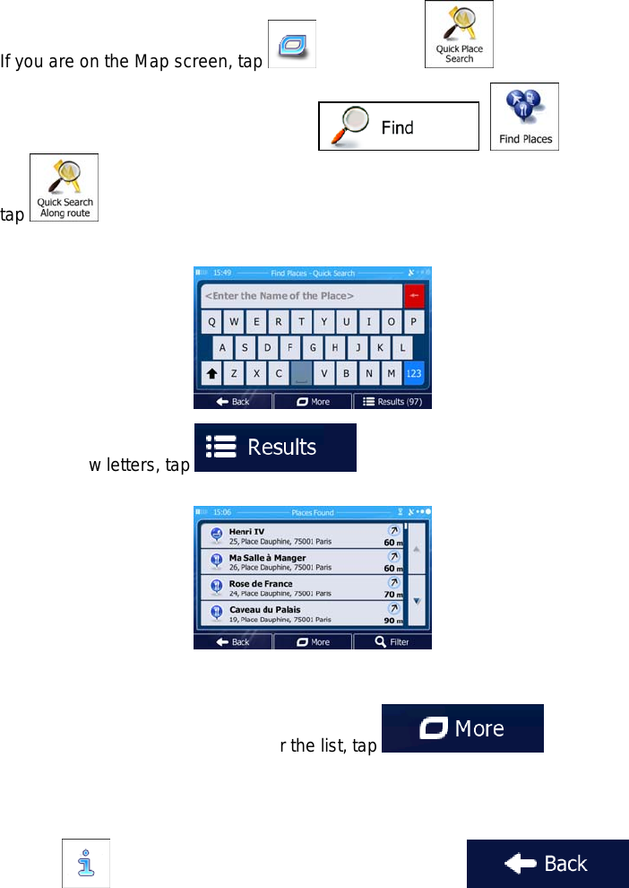
3.1.2.1 Quick search for a Place of Interest
The Quick search feature lets you quickly find a Place by its name. The search is always
carried out
along the recommended route if it exists or
around your current location if there is no destination given.
1. Start the Quick search function:
If you are on the Map screen, tap and then tap .
If you are in the Navigation menu, tap , and then
tap .
2. Using the keyboard, start entering the name of the Place.
3. After entering a few letters, tap to open the list of Places with
names containing the entered character sequence.
4. (optional) The Places in the list are ordered by the length of the necessary detour
(when navigating a route) or by their distance from the current position (when no
destination is given). If you need to reorder the list, tap .
5. Browse the list if necessary and tap one of the list items. A full screen map appears
with the selected point in the middle. The name and address of the Place is displayed
at the top of the screen.
6. (optional) Tap to see the details of the selected Place. Tap
to return to the map.
Termékspecifikációk
| Márka: | Igo |
| Kategória: | Szoftver |
| Modell: | Primo Navigation - Macrom Mobile Multimedia |
Szüksége van segítségre?
Ha segítségre van szüksége Igo Primo Navigation - Macrom Mobile Multimedia, tegyen fel kérdést alább, és más felhasználók válaszolnak Önnek
Útmutatók Szoftver Igo

22 Augusztus 2024
20 Augusztus 2024
Útmutatók Szoftver
- Szoftver Canon
- Szoftver Omron
- Szoftver Apple
- Szoftver Microsoft
- Szoftver Zoom
- Szoftver Google
- Szoftver IRiver
- Szoftver Corel
- Szoftver Cyberlink
- Szoftver Adobe
- Szoftver Roxio
- Szoftver Acronis
- Szoftver Acoustica
- Szoftver Android
- Szoftver Nero
- Szoftver Envivo
- Szoftver Safescan
- Szoftver SMA
- Szoftver Bticino
- Szoftver Minolta
- Szoftver Pinnacle
- Szoftver Teasi
- Szoftver AVG
- Szoftver Suse
- Szoftver FileMaker
- Szoftver Lebara
- Szoftver Magix
- Szoftver Ulead
- Szoftver Fiber
- Szoftver Image-Line
- Szoftver Davilex
- Szoftver Skype
- Szoftver Osirius
- Szoftver Hercules
- Szoftver SAB
- Szoftver LibreOffice
- Szoftver Route 66
- Szoftver Trend Micro
- Szoftver Office
- Szoftver BlueGriffon
- Szoftver Startech
- Szoftver Enfocus
- Szoftver Wolters Kluwer
- Szoftver TeamViewer
- Szoftver Techsmith
- Szoftver Serif
- Szoftver Nedsoft
- Szoftver FreakinSoftMania
- Szoftver Solcon
- Szoftver Macromedia
- Szoftver DraftSight
- Szoftver ZTE Blade V8
- Szoftver Stentec
- Szoftver Foveon
- Szoftver Enra
Legújabb útmutatók Szoftver

14 Január 2025
14 Október 2024
13 Október 2024
10 Október 2024
7 Október 2024
5 Október 2024
5 Október 2024
5 Október 2024
23 Szeptember 2024
22 Szeptember 2024