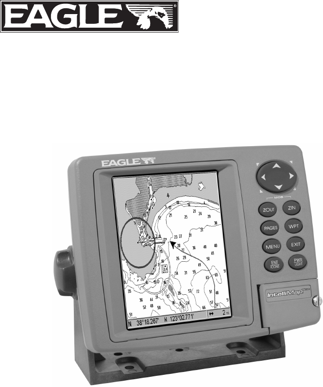
Használati útmutató Eagle IntelliMap 642c iGPS Mapping GPS Receiver
Olvassa el alább 📖 a magyar nyelvű használati útmutatót Eagle IntelliMap 642c iGPS Mapping GPS Receiver (132 oldal) a Navigáció kategóriában. Ezt az útmutatót 13 ember találta hasznosnak és 2 felhasználó értékelte átlagosan 4.5 csillagra
Oldal 1/132
Pub. 988-0152-161
www.eaglegps.com
IntelliMap 642c iGPS
Mapping GPS Receiver
Installation and Operation
Instructions
®

Copyright © 2005 LEI-Eagle
All rights reserved.
No part of this manual may be copied, reproduced, republished,
transmitted or distributed for any purpose, without prior written
consent of Eagle Electronics. Any unauthorized commercial
distribution of this manual is strictly prohibited.
Eagle® is a registered trademark of LEI. MapCreate, FreedomMaps
and NauticPath are trademarks of LEI. Fishing Hot Spots is a
registered trademark of Fishing Hot Spots Inc. LakeMaster and
ProMaps are trademarks or registered trademarks of Waypoint
Technologies, Inc. Navionics is a registered trademark of Navionics,
Inc.
eXitSource Database, copyright 2001-2005 Zenrin Co.
Ltd. Exit Authority and eXitSource are trademarks of
Zenrin Co. Ltd.
Eagle Electronics may find it necessary to change or end our policies,
regulations and special offers at any time. We reserve the right to do so
without notice. All features and specifications subject to change without
notice. All screens in this manual are simulated.
For free owner's manuals and the most current information on
this product, its operation and accessories,
visit our web site:
www.eaglegps.com
Eagle Electronics
P.O. Box 669
Catoosa, OK USA 74015
Printed in USA.
i
Table of Contents
Section 1: Read Me First!............................................................... 1
Capabilities and Specifications: ......................................................... 2
How GPS Works ................................................................................. 4
Introduction to GPS and WAAS......................................................... 6
How to use this manual: typographical conventions ........................ 8
Arrow Keys ...................................................................................... 8
Keyboard.......................................................................................... 8
Menu Commands ............................................................................ 8
Instructions = Menu Sequences ..................................................... 8
Section 2: Installation & Accessories....................................... 11
Preparations...................................................................................... 11
Power Connections ........................................................................... 11
NMEA Cable Connections................................................................ 14
NMEA Wiring................................................................................ 14
Mounting the Unit: Bracket or Portable ......................................... 14
MMC or SD Card Memory Card Installation.................................. 17
Other Accessories ............................................................................. 18
Section 3: Basic GPS Operations ............................................... 21
Keyboard ........................................................................................... 21
Power/lights on and off..................................................................... 22
Main Menu........................................................................................ 22
Pages ................................................................................................. 24
Satellite Status Page .................................................................... 24
Navigation Page ............................................................................ 26
Map Page ....................................................................................... 28
Background map vs. MapCreate map content............................. 30
Resize Window command ............................................................. 32
Basic GPS Quick Reference.............................................................. 34
Moving Around the Map: Zoom & Cursor Arrow Keys................... 35
Selecting Any Map Item With the Cursor ....................................... 36
Searching .......................................................................................... 36
Set a Waypoint.................................................................................. 38
Navigate To a Waypoint................................................................... 41
Set Man Overboard (MOB) Waypoint ............................................. 42
Navigate Back to MOB Waypoint.................................................... 42
Navigate to Cursor Position on Map................................................ 43
Navigate to a Point of Interest......................................................... 44
Creating and Saving a Trail............................................................. 44
Displaying a Saved Trail .................................................................. 46
Navigating Trails.............................................................................. 46
Visual Trailing .............................................................................. 47
ii
Navigate a Trail ............................................................................ 47
Navigate a Back Trail................................................................... 49
Transfer Custom Maps and GPS Data Files................................... 50
Cancel Navigation ............................................................................ 52
Section 4: Advanced GPS Operations...................................... 53
Find Distance Current Position to Another Location ..................... 53
Find Distance From Point to Point.................................................. 53
Icons .................................................................................................. 54
Create Icon on Map....................................................................... 54
Create Icon at Current Position ................................................... 54
Delete an Icon................................................................................ 54
Navigate to an Icon ....................................................................... 55
Routes................................................................................................ 55
Create and Save a Route .............................................................. 56
Delete a Route ............................................................................... 58
Edit a Route Name........................................................................ 59
Edit Route Waypoints................................................................... 59
Navigate a Route........................................................................... 59
Navigate a Route in Reverse ........................................................ 61
Trails ................................................................................................. 62
Delete a Trail................................................................................. 62
Edit a Trail Name ......................................................................... 62
Edit a Trail Color .......................................................................... 62
Edit a Trail Pattern ...................................................................... 63
Utilities ............................................................................................. 63
Alarm Clock................................................................................... 63
Sun/Moon Rise & Set Calculator.................................................. 63
Trip Calculator .............................................................................. 63
Trip Down Timer........................................................................... 63
Trip Up Timer ............................................................................... 63
Waypoints ......................................................................................... 64
Delete a Waypoint......................................................................... 64
Edit a Waypoint ............................................................................ 64
Selecting a Waypoint .................................................................... 65
Set a Waypoint by Average Position ............................................ 65
Set a Waypoint by Projecting a Position...................................... 65
Section 5: System & GPS Setup Options .................................. 67
Alarms ............................................................................................... 67
Check MMC Files and Storage Space.............................................. 68
Communications Port Configuration............................................... 68
Configure NMEA .............................................................................. 69
Coordinate System Selection ........................................................... 70
Customize Page Displays ................................................................. 71
iii
GPS Simulator .................................................................................. 72
Initialize GPS.................................................................................... 74
Map Auto Zoom................................................................................. 74
Map Data .......................................................................................... 74
Earth Map Detail .......................................................................... 75
Pop-up Map Information .............................................................. 75
Draw Map Boundaries .................................................................. 75
Fill Water With White .................................................................. 75
Map Overlays (Range Rings; Lat/Long Grid) .............................. 75
Map Datum Selection ....................................................................... 76
Map Detail Category Drawn ............................................................ 77
Map Fix ............................................................................................. 77
Map Orientation ............................................................................... 79
NauticPath USA Marine Charts................................................... 80
Nautical Chart Notes.................................................................... 80
Port Information ........................................................................... 81
Tidal Current Information............................................................ 82
Tide Information ........................................................................... 84
Navionics Charts............................................................................. 85
Overlay Data..................................................................................... 86
Pop-up Help ...................................................................................... 88
Reset Options.................................................................................... 89
Require WAAS .................................................................................. 89
Screen Contrast and Brightness ...................................................... 90
Set Language .................................................................................... 91
Set Local Time .................................................................................. 91
Show WAAS Alarm........................................................................... 91
Software Version Information.......................................................... 92
Sounds Menu .................................................................................... 92
Track Smoothing............................................................................... 93
Trail Options..................................................................................... 93
Delete All Trails ............................................................................ 94
Update Trail Option...................................................................... 94
Update Trail Criteria.................................................................... 94
Trail Update Rate ......................................................................... 94
Delete Trail.................................................................................... 95
New Trail....................................................................................... 95
Trail Visibility and Other Trail Options...................................... 95
Transparency .................................................................................... 96
Units of Measure .............................................................................. 97
Section 6: Searching ..................................................................... 99
Find Addresses ............................................................................... 100
Find Any Item Selected by Map Cursor ........................................ 103
iv
Find Interstate Highway Exits ...................................................... 103
Find Map Places or Points of Interest (POI) ................................. 105
Find Streets or Intersections ......................................................... 107
Find a Street ............................................................................... 107
Find an Intersection.................................................................... 108
Find Waypoints............................................................................... 110
Section 7: Supplemental Material ........................................... 113
WARNING!
A CAREFUL NAVIGATOR NEVER RELIES ON ONLY ONE METHOD
TO OBTAIN POSITION INFORMATION.
CAUTION
When showing navigation data to a position (waypoint), a GPS unit will show
the shortest, most direct path to the waypoint. It provides navigation data to the
waypoint regardless of obstructions. Therefore, the prudent navigator will not
only take advantage of all available navigation tools when traveling to a way-
point, but will also visually check to make sure a clear, safe path to the waypoint
is always available.
WARNING!
When a GPS unit is used in a vehicle, the vehicle operator is solely re-
sponsible for operating the vehicle in a safe manner. Vehicle operators
must maintain full surveillance of all pertinent driving, boating or fly-
ing conditions at all times. An accident or collision resulting in damage
to property, personal injury or death could occur if the operator of a
GPS-equipped vehicle fails to pay full attention to travel conditions and
vehicle operation while the vehicle is in motion.
1
Section 1: Read Me First!
How this manual can get you out on the road, fast!
Welcome to the exciting world of digital GPS! We know you're anxious
to begin navigating, but we have a favor to ask. Before you grab the
IntelliMap® 642c iGPS and begin installing it, please give us a moment
or two to explain how our manual can help you get the best perform-
ance from your compact, wide-screen, mapping GPS receiver.
First, we want to thank you for buying an Eagle GPS unit. Whether
you're a first time user or a professional fisherman, you'll discover that
your IntelliMap 642c iGPS is easy to use, yet capable of handling de-
manding navigation tasks. When you team your unit with our custom
mapping software MapCreate 6, you have an incredible combination.
You won't find another GPS unit with this much power and this many
features for this price!
Our goal for this book is to get you on the road fast, with a minimum of
fuss. Like you, we'd rather spend more time navigating and less time
reading the manual!
So, we designed our book so that you don't have to read the whole thing
from front to back for the information you want. At the start (or end) of
each segment, we'll tell you what content is coming up next. If it's a
concept you're already familiar with, we'll show you how and where to
skip ahead for the next important topic. We've also made it easy to look
up any tips you may need from time to time. Here's how:
The manual is organized into 7 sections. This first section is an intro-
duction to Eagle GPS. It tells you the basics you need to know before
you can make the unit look around and tell you where you are.
Section 2 will help you install your unit. We'll show you how to get the
MultiMedia Card (MMC) correctly installed inside the unit. We'll also
tell you about some of the available accessories.
Section 3 covers Basic GPS Operation. It will show you how easy it is to
run the IntelliMap 642c, right out of the box. This section features a
one-page GPS Quick Reference. (If you've already jumped ahead
and figured out how to install the unit yourself, and you just
can't wait any longer, turn to the Quick Reference on page 34
and head for the road with your GPS unit!)
Section 3 contains short, easy-to-scan GPS lessons that follow one an-
other in chronological order. They're all you'll need to know to find your
way on the water or in the wilderness quickly.
3
Case size:......................... 5.4" H x 6.9" W x 3.4" D (13.8 x 17.6 x 8.6
cm); sealed and waterproof; suitable for
saltwater use.
MMC slots: ...................... One with waterproof door (SD card
compatible).
Recording:........................ MMC & SD cards for recording GPS trip de-
tails and displaying charts or custom maps.
Back-up memory: .......... Built-in memory stores GPS data for dec-
ades. User settings are stored when unit is
turned off.
Languages:...................... 10; menu languages selectable by user.
GPS
Receiver/antenna: ......... Internal; Built-in 12 parallel channel
GPS/WAAS .
Background map:.......... Built-in custom, detailed Eagle map. Con-
tains: enhanced detail of continental U.S.
and Hawaii. Includes more than 60,000 nav
aids and 10,000 wrecks/obstructions in
coastal and Great Lakes waters. Metro
areas, selected major streets/highways and
interstate exit services details included.
Custom mapping: .......... MapCreate 6 software optional; optional
plug and play LEI FreedomMaps offer the
same high-detail without the computer work
of MapCreate. Other plug and play mapping
options include Fishing Hot Spots Elite,
LakeMaster Pro Maps, LEI NauticPath
marine charts and Navionics marine charts.
Mapping memory: ......... Up to 2 gigabytes on one MMC (or SD) card.
Position updates: .......... Every second.
Position points: ............. 1,000 waypoints; 1,000 event marker icons.
Audible alarms: ............. Arrival/off-course/anchor.
Graphic symbols for
waypoints or event
marker icons: ................. 42.
Routes:............................. 100, up to 100 waypoints per route.
Plot Trails: ...................... 10 savable; up to 10,000 points per trail.
Zoom range:.................... 40 ranges; 0.02 to 4,000 miles.
4
NOTE:
The above memory capacities refer only to the IntelliMap 642c's on-
board memory. The amount of GPS data you can record and save for
recall later is limited only by the number and size of MMC cards you
have.
NOTICE!
The storage temperature range for your IntelliMap 642c is from -4
degrees to +167 degrees Fahrenheit (-20 degrees to +75 degrees
Celsius). Extended storage in temperatures higher or lower than
specified will damage the liquid crystal display in your unit. This
type of damage is not covered by the warranty. For more informa-
tion, contact the factory's Customer Service Department; phone
numbers are listed on the last page of this manual.
How GPS Works
You'll navigate faster and easier if you understand how the IntelliMap
642c scans the sky to tell you where you are on the earth – and, where
you're going. (But if you already have a working understanding of GPS
receivers and the GPS navigation system, skip on ahead to Section 2,
Installation & Accessories on page 11. If you're new to GPS, read on.
You can later impress your friends with your new-found knowledge.)
First, think of your unit as a small but powerful computer. (But don't
worry — we made it easy to use, so you don't need to be a computer ex-
pert to find your way!) The IntelliMap 642c includes a keypad and a
screen with menus so you can tell it what to do. The screen also lets the
unit show your location on a moving map, as well as point the way to
your destination.
This gimbal-mounted IntelliMap 642c uses an internal an-
tenna/receiver module, which makes the whole system work something
like your car radio. But instead of your favorite dance tunes, this re-
ceiver tunes in to a couple of dozen GPS satellites circling the earth. (It
will also listen in to the WAAS satellites in orbit, but more about that
in the upcoming segment introducing you to GPS and WAAS.)
Your unit listens to signals from as many satellites as it can "see" above
the horizon, eliminates the weakest signals, then computes its location
in relation to those satellites. Once the IntelliMap 642c figures its lati-
tude and longitude, it plots that position on the moving map shown on
the screen. The whole process takes place several times a second!
The performance doesn't stop there. Stored in the permanent memory
of each unit is a basic background map of the entire world. We lock it in
here at the factory — you can't change or erase this map.
5
The background map is suitable for many navigation chores, but for
maximum accuracy and much more detail, you need our optional map-
making software, MapCreate 6, or one of our special plug-and-play
mapping cards. Some unit features — such as searching for businesses
and addresses — won't work without a custom MapCreate map. There
is so much detail in our background map (and even more in MapCreate)
that we'll describe their contents and differences in Section 3, Basic
GPS Operations, on page 30.
Another portion of the IntelliMap 642c's onboard memory is devoted to
recording GPS navigation information, which includes waypoints, event
marker icons, trails and routes. This lets you look back the way you came.
Think of this data storage like the hard drive memory in a computer or a
tape in a cassette tape recorder. You can save several different GPS data
files, erase 'em and record new ones, over and over again. Like any com-
puter file, these GPS Data Files (file format *.usr) can be shared be-
tween Eagle GPS or sonar/GPS units or even personal computers.
This IntelliMap 642c has one more thing in common with a personal
computer. Just as computers have a floppy disk drive for storing and ex-
changing files, the unit has a slot for an MMC (MultiMedia Card) or SD
card (Secure Digital card) flash memory card. These solid-state memory
devices are about the size of a postage stamp, but can hold data ranging
from 8 MB to 1 GB in size. (Compare that to a floppy disk's 1.44 MB ca-
pacity!) This unit uses all that MMC space for two key GPS purposes.
First, you can backup your onboard GPS Data Files by copying them to
the MMC. Since the MMC is removable (like a floppy disk or a cassette
tape), you can store these GPS Data Files on a personal computer
equipped with an MMC card reader. (Or store them on a pocketful of
MMCs, if you don't have a computer.) Our MapCreate mapping software
can save, edit or create its own GPS Data Files, which can be copied to the
MMC and then loaded from the MMC into the unit's memory. (NOTE: No
matter where they come from, GPS Data Files must be loaded from the
MMC into memory before the IntelliMap 642c can use them.)
The other key GPS use for MMCs is storage of special high-detail, cus-
tom maps, which you can produce on your computer with our MapCre-
ate software. These MapCreate custom maps contain much greater de-
tail than the basic background map. These Custom Map Files (file
format *.lcm) can also be shared between Eagle GPS or sonar/GPS
units and personal computers.
This unit automatically reads Custom Map Files directly from the
MMC or SD card. To use a custom map, all you need to do is slide an
MMC containing a map into the IntelliMap 642c.
7
The system requires signal reception from three satellites in order to
determine a position. This is called a 2D fix. It takes four satellites to
determine both position and elevation (your height above sea level —
also called altitude). This is called a 3D fix.
Remember, the unit must have a clear view of the satellites in order to
receive their signals. Unlike radio or television signals, GPS works at
very high frequencies. These signals can be easily blocked by trees,
buildings, an automobile roof, even your body.
Like most GPS receivers, this unit doesn’t have a compass or any other
navigation aid built inside. It relies solely on the signals from the sat-
ellites to calculate a position. Speed, direction of travel, and distance
are all calculated from position information. Therefore, in order for the
IntelliMap 642c to determine direction of travel, you must be moving
and the faster, the better. This is not to say that it won’t work at
walking or trolling speeds — it will. There will simply be more "wan-
dering" of the data shown on the display.
GPS alone is plenty accurate for route navigation, but the U.S. Federal
Aviation Administration has special aircraft navigation needs that go
beyond basic GPS. Consequently, the FAA has developed a program to
boost GPS performance with its Wide Area Augmentation System
(WAAS). The FAA commissioned the system on July 11, 2003.
WAAS is designed to increase GPS accuracy to within 7.6 meters verti-
cally and horizontally, but according to the FAA, it consistently comes
within 1-2 meters horizontally and 2-3 meters vertically. It does this by
broadcasting correction signals on GPS frequencies. Your unit auto-
matically receives both GPS and WAAS signals.
There are, however, some fringe areas of the U.S., including parts of
Alaska, that do not yet receive robust WAAS coverage. Continued
WAAS development is planned to extend WAAS coverage in the years
to come.
WAAS boosts the accuracy of land GPS navigation, but the system is
designed for aircraft. The satellites are in a fixed orbit around the
Equator, so they appear very low in the sky to someone on the ground
in North America. Aircraft and vessels on open water can get consis-
tently good WAAS reception, but terrain, foliage or even large man-
made structures can sometimes block the WAAS signal from ground
receivers.
You'll find that using your GPS receiver is both easy and amazingly
accurate. It’s easily the most accurate method of electronic navigation
available to the general public today.
8
Remember that this receiver is only a tool. Always have another
method of navigation available, such as a map or chart and a compass.
Also remember that this unit will always show navigation information
in the shortest line from your present position to a waypoint, regardless
of terrain! It only calculates position, it can’t know what’s between you
and your destination, for example. It’s up to you to safely navigate
around obstacles, no matter how you’re using this product.
How to use this manual: typographical conventions
Many instructions are listed as numbered steps. The keypad and arrow
"keystrokes" appear as boldface type. So, if you're in a real hurry (or
just need a reminder), you can skim the instructions and pick out what
menu command to use by finding the boldface command text. The fol-
lowing paragraphs explain how to interpret the text formatting for
those commands and other instructions:
Arrow Keys
The arrow keys control the movement of dotted cross-hair lines on your
mapping screen called the cursor. The arrow keys help you move
around the menus so you can execute different commands. They are
represented by symbols like these, which denote the down arrow key,
the up arrow, the left arrow and the right arrow: ↓ ↑ ← →.
Keyboard
The other keys perform a variety of functions. When the text refers to a
key to press, the key is shown in bold, sans serif type. For example, the
"Enter/Icons" key is shown as ENT and the "Menu" key is shown as
MENU.
Menu Commands
a menu command or a menu option will appear in small capital letters,
in a bold sans serif type like this: ROUTE PLANNING. These indicate that
you are to select this command or option from a menu or take an action
of some kind with the menu item. Text that you may need to enter or
file names you need to select are show in italic type, such as trail name.
Instructions = Menu Sequences
Most functions you perform with this unit are described as a sequence
of key strokes and selecting menu commands. We've written them in a
condensed manner for quick and easy reading.
For example, instructions for navigating a trail would look like this:
1. From the Map Page, press MENU|MENU|↓ to MY TRAILS|ENT.
2. Press ↓ to Trail 1|ENT|→|↓ to NAVIGATE|ENT.
3. You are asked to wait while it converts the trail into a route.

11
Section 2:
Installation & Accessories
Preparations
You can install the GPS system in some other order if you prefer, but
we recommend this installation sequence:
Caution:
You should read over this entire installation section before drill-
ing any holes in your vehicle or vessel!
1. Determine the approximate location for the GPS unit, so you can
plan how and where to route the power cable. This will help you make
sure you have enough cable length for the desired configuration.
2. Determine the location of your battery or other power connection,
along with the power cable route.
3. Install the power cable and route it to the GPS unit.
4. Mount the GPS unit.
The IntelliMap 642c uses an internal antenna to achieve a GPS
lock. In order to get a strong signal, you need to select a mount-
ing location that has a clear, unobstructed view of the sky.
NOTE:
The IntelliMap 642c is designed for open-cockpit boats, but the unit
will probably work in an automobile or a closed-cockpit boat if it's
mounted with a clear view through the windshield or other win-
dows. This probably will not work if you have a cab-over design
pickup truck camper or motor home, or a boat cabin with limited
visibility. Remember: for optimum operation, this unit should be
mounted in the open with nothing obstructing its view of the sky.
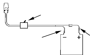
Power Connections
The IntelliMap 642c works from a 12-volt battery system. For the best
results, attach the power cable directly to the battery. You can attach
the power cable to an accessory or power bus, but you might have
problems with electrical interference. Therefore, it's safer to go ahead
and attach the power cable directly to the battery.
CAUTION:
When using the unit in a saltwater environment, we strongly rec-
ommend that you shut off the power supply to the power cable when
the unit is not in use. When the unit is turned off but still connected
to a power supply, electrolysis can occur in the power cable plug.
12
This may result in corrosion of the plug body along with the electri-
cal contacts in the cable and the unit's power socket.
In saltwater environments we recommend you connect the power
cable to the auxiliary power switch included in most boat designs.
If that results in electrical interference, or if such a switch is not
available, we recommend connecting direct to the battery and in-
stalling an inline switch. This will let you shut off power to the
power cable when the unit is not in use. When you are not using
the unit, you should always shut off power to the power cable, es-
pecially when the power cable is disconnected from the unit.
If possible, keep the power cable away from other boat wiring, espe-
cially the engine's wires. This will provide the best isolation from elec-
trical noise. If the cable is not long enough, splice #18 gauge wire onto
it. The power cable has two wires, red and black. Red is the positive
lead, black is negative or ground. Make sure to attach the in-line fuse
holder to the red lead as close to the power source as possible.
For example, if you have to extend the power cable to the battery or
power buss, attach one end of the fuse holder directly to the battery or
power buss. This will protect both the unit and the power cable in the
event of a short. It uses a 3-amp fuse.
Power connections for the IntelliMap 642c GPS unit.
WARNING:
This product must be independently fused with the en-
closed 3-amp fuse (or equivalent), even if you connect to
a fused accessory or power buss.
If a malfunction happens inside the unit, extensive dam-
age can occur if the enclosed fuse is not used. As with all
electrical devices, this unit could be damaged to a point
that it is not repairable and could even cause harm to the
user when not properly fused.
12 volt
battery
Red wire with
3 amp fuse
To unit
Black wire
Optional power off switch for
saltwater installations

13
CAUTION:
Failure to use the enclosed 3-amp fuse will void your warranty! For
a replacement, use a type 3AG 3-amp fuse.
This unit has reverse polarity protection. No damage will occur if the
power wires are reversed. However, the unit will not work until the
wires are attached correctly.
Cable connections.
3-amp fuse
Rear view of unit
Power Connector
NMEA 0183
Com Port
Power cable
Com port
data wires
(three)
12-volt battery
Termékspecifikációk
| Márka: | Eagle |
| Kategória: | Navigáció |
| Modell: | IntelliMap 642c iGPS Mapping GPS Receiver |
Szüksége van segítségre?
Ha segítségre van szüksége Eagle IntelliMap 642c iGPS Mapping GPS Receiver, tegyen fel kérdést alább, és más felhasználók válaszolnak Önnek
Útmutatók Navigáció Eagle

23 Augusztus 2024
Útmutatók Navigáció
- Navigáció Grundig
- Navigáció Pioneer
- Navigáció Kia
- Navigáció Garmin
- Navigáció JVC
- Navigáció Volvo
- Navigáció Toyota
- Navigáció Medion
- Navigáció Mazda
- Navigáció Skoda
- Navigáció Kenwood
- Navigáció Audi
- Navigáció Navitel
- Navigáció Seat
- Navigáció Raymarine
- Navigáció Parrot
- Navigáció Tacx
- Navigáció Sygic
- Navigáció Prestigio
- Navigáció Mio
- Navigáció TomTom
- Navigáció Mappy
- Navigáció GlobalTronics
- Navigáció Zenec
- Navigáció GoClever
- Navigáció Packard Bell
- Navigáció A-Rival
- Navigáció Apelco
- Navigáció LX NAV
- Navigáció Marquant
- Navigáció Binatone
- Navigáció Magellan
- Navigáció TakeMS
- Navigáció Audiovox
- Navigáció Navigon
- Navigáció Targa
- Navigáció Hagenuk
- Navigáció Autovision
- Navigáció Navman
- Navigáció Sungoo
- Navigáció Simrad
- Navigáció Danew
- Navigáció Snooper
- Navigáció VDO Dayton
- Navigáció Macrom
- Navigáció Becker
- Navigáció Fujitsu Siemens
- Navigáció Igo
- Navigáció Bluetech
- Navigáció Route 66
- Navigáció Falk
- Navigáció Seecode
- Navigáció Nav N Go
- Navigáció Bullit
- Navigáció Viamichelin
- Navigáció Xzent
- Navigáció Navteq
- Navigáció Igo 8
- Navigáció Keomo
- Navigáció RoHS
- Navigáció Invion
- Navigáció VW
- Navigáció Raystar
- Navigáció Eclipse
- Navigáció Holux
- Navigáció PENTAGRAM
- Navigáció Roadnavigator
- Navigáció WayteQ
- Navigáció GoRider
Legújabb útmutatók Navigáció
15 Január 2025
12 Január 2025
5 Október 2024
5 Október 2024
5 Október 2024
5 Október 2024
5 Október 2024
5 Október 2024
23 Szeptember 2024
21 Szeptember 2024