Használati útmutató Blaupunkt 73
Olvassa el alább 📖 a magyar nyelvű használati útmutatót Blaupunkt 73 (112 oldal) a Navigator kategóriában. Ezt az útmutatót 10 ember találta hasznosnak és 2 felhasználó értékelte átlagosan 4.5 csillagra
Oldal 1/112

Instruction Manual
TravelPilot 43 / 53 / 73
TravelPilot 54 / 74

User’s Guide
Navigation Software-
Blaupunkt Travel Pilot
English
mei – 17.02.2012
Thank you for buying the Blaupunkt navigation system. A good choice.
We wish you a lot of fun and congestion-free kilometres with your new Blaupunkt
navigation system. In the worst case we will help you.
For technical questions / problems, please contact us : support@first-servicecenter.de,
facebook.com/BlaupunktDACH, www.blaupunkt.de
The manual for other full languages or additional manuals (depending on your model)
can be downloaded www.blaupunkt.de at
Please register your product as soon as possible on our website. This will give you
benefits such as latest software and the latest map data, etc. – Most of it, of course,
for free.

Dear Customer,
Thanks for using a navigation system of Blaupunkt.
• Blaupunkt reserves the rights of final interpretation of the manual.
• The product is subject change without notice. Please accept our apology for your inconvenience.
• Please back up your data and information in the GPS navigator. Blaupunkt assumes no responsibility
for any loss caused by material loss.
• The manual might contain a few mistakes though it has been checked. If any mistake is found, please
contact the Blaupunkt customer service center. Please read the instructions in this manual and use only
accessories of Blaupunkt to avoid unpredicted damage. Failure to follow the instructions will invalidate
warranty and might endanger personnel safety, for which Blaupunkt assumes no responsibility.
• Data of navigation electronic maps might be inconsistent with actual traffic signals due to transportation
development. Please follow traffic regulations and signs and drive according to road situation. Operating
the GPS navigator device while driving might cause serious accidents. Blaupunkt assumes no responsibility
for accidents and loss due to improper use.
• For information of software update and upgrade, please go to our website www.blaupunkt.de
In case that your navigation-system contains a built-in TMC-receiver for reception of traffic-information, its
antenna is integrated into car-charge-cable. For correct reception of traffic-information, the car-charger
needs to be connected to the USB-port of the navigation-system!
Please use your device to operate ONLY a blunt stylus or fingertip. The screen surface is easily scratched.
To operate any sharp objects or long fingernails.
For your own safety, do not operate the controls of the product while driving.
Use this product prudently. The product is intended to be used only as a navigation aid. It is not for precise
measurement of direction, distance, location or topography.
The calculated route is for reference only. It is the user’s responsibility to follow the traffic signs and local
regulations along the road.
When you get off the car, do not leave your device on the dashboard that is subject to direct sunlight. The overheating
of the battery can cause malfunction and /or danger.
GPS is operated by the United States government, which is solely responsible for the performance of GPS.
Any change to the GPS system can affect the accuracy of all GPS equipments.
GPS satellite signal can not pass through solid materials (except glass). When you are inside a tunnel or building,
GPS positioning is not available.
A minimum of 4 GPS satellite signal is needed to determine current GPS position. Signal reception can be affected by
situations such as bad weather or dense overhead obstacles (e.g. trees and tall buildings).
Other wireless devices in the vehicle might interface with the reception of satellite signals and cause the reception to
be unstable.
A car holder id needed when using the device in a car. Be sure to place the device in an appropriate place, so as
not to obstruct the driver’s view or deployment of air bag.

3
Table of contents
1 Warnings and Safety information ........................................................................... 6
2 Getting started ........................................................................................................... 7
2.1 Navigation menu ............................................................................................................... 8
2.2 Buttons and other controls on the screen .......................................................................... 9
2.2.1 Using keyboards ................................................................................................................... 10
2.2.2 Beyond single screen tap ...................................................................................................... 11
2.3 Map screen ...................................................................................................................... 12
2.3.1 Navigating on the map .......................................................................................................... 12
2.3.2 Position markers ................................................................................................................... 14
2.3.2.1 Vehimarker and Lock-on- Road ..................................................................................................... 14
2.3.2.2 Selected map location (Cursor) and selected map object ............................................................. 14
2.3.3 Objects on the map ............................................................................................................... 14
2.3.3.1 Streets and roads .......................................................................................................................... 14
2.3.3.2 Turn preview and Next street ........................................................................................................ 15
2.3.3.3 Lane information and Signposts.................................................................................................... 16
2.3.3.4 Junction view ................................................................................................................................ 17
2.3.3.5 Motorway exit services ................................................................................................................. 17
2.3.3.6 3D object types.............................................................................................................................. 17
2.3.3.7 Elements of the active route .......................................................................................................... 18
2.3.3.8 Traffic events................................................................................................................................. 19
2.3.4 Manipulating the map ........................................................................................................... 20
2.3.5 Quick menu ........................................................................................................................... 21
2.3.6 Checking the details of the current position (Where Am I?) ................................................ 24
3 On-road navigation ................................................................................................. 26
3.1 Selecting the destination of a route ................................................................................. 26
3.1.1 Combined Search .................................................................................................................. 26
3.1.1.1 Combined Search ating to a recent destination (History)- Navig ................................................. 29
3.1.1.2 Combined Search - Navigating to a Favourite destination ........................................................... 30
3.1.1.3 Combined Search Navigating to an address- ............................................................................... 30
3.1.1.4 Combined Search Navigating to an intersection- ........................................................................ 31
3.1.1.5 Combined Search - Navigating to a Place of Interest ................................................................... 32
3.1.1.6 Combined Search Navigating to a Place of Interest by its category- ........................................... 33
3.1.2 Entering an address or a part of the address .......................................................................... 34
3.1.2.1 Entering an address ...................................................................................................................... 34
3.1.2.2 Entering the midpoint of a street as the destination ...................................................................... 37
3.1.2.3 Selecting an intersection as the destination .................................................................................. 38
3.1.2.4 Selecting a city/town centre as the destination.............................................................................. 39
3.1.2.5 Entering an address with a postal code ........................................................................................ 41
3.1.2.6 Tips on entering addresses quickly ............................................................................................... 43
3.1.3 Selecting the destination from the Places of Interest ............................................................ 43
3.1.3.1 Quick search for a Place of Interest.............................................................................................. 44

4
3.1.3.2 Searching for a Place of Interest using preset categories ............................................................. 45
3.1.3.3 Searching for a Place of Interest by category ............................................................................... 47
3.1.3.4 Searching for a Place of Interest by name .................................................................................... 50
3.1.3.5 Selecting nearby assistance from 'Where Am I?'........................................................................... 52
3.1.4 Selecting a map location as the destination........................................................................... 54
3.1 .....................................................................5 Selecting the destination from your Favourites 55
3.1.6 Selecting one of the most likely destinations (Smart History) .............................................. 56
3.1.7 Selecting a recent destination from the History .................................................................... 57
3.1.8 Entering the coordinate of the destination ............................................................................ 58
3.1.9 Navigate to a location stored in a photo................................................................................ 59
3.1.10 Building a route from the list of destinations (Create Route) ............................................. 60
3.2 Viewing the entire route on the map ............................................................................... 61
3.3 Checking route parameters and accessing route related functions ................................ 61
3.4 Modifying the route ......................................................................................................... 62
3.4.1 Selecting a new destination when already having a route: New Route, Waypoint or Final
Destination ....................................................................................................................................... 62
3.4.2 Setting a new starting position for the route ......................................................................... 63
3.4.3 Editing the list of destinations (Edit Route) .......................................................................... 64
3 .4.4 Pausing the active route ........................................................................................................ 65
3.4.5 Cancelling the active route.................................................................................................... 65
3.4.6 Checking route alternatives when planning the route ........................................................... 66
3.4.7 Checking route alternatives for an existing route . ................................................................ 67
3.4.8 Changing the vehicle used in route planning ........................................................................ 68
3.4.9 Changing the road types used in route planning ................................................................... 69
3.5 Saving a location as a Favourite destination .................................................................. 70
3.5.1 Editing the details of a Favourite destination ........................................................................ 71
3.6 Saving a map location as an alert point ......................................................................... 72
3.7 Editi ...................................................................................................... 73ng an alert point
3.8 Watching the simulation of the route .............................................................................. 74
4 Off-road navigation ................................................................................................. 76
4.1 Selecting the destination of the route .............................................................................. 76
4.2 Navigat - ........................................................................................... 76ing in off road mode
5 Lorry navigation...................................................................................................... 77
5.1 Setting up vehicle parameters ......................................................................................... 77
5.2 Setting up waiting time at waypoints .............................................................................. 79
5.3 Setting u .......................................................................................... 80p driving time alerts
6 Reference Guide ...................................................................................................... 81
6.1 Concepts .......................................................................................................................... 81
6.1.1 Smart Zoom .......................................................................................................................... 81
6.1.2 Daytime and night colour themes ......................................................................................... 81
6.1.3 Route calculation and recalculation ...................................................................................... 81

5
6.1.4 Green routing ........................................................................................................................ 83
6.1.5 Road safety cameras and other proximity alert points .......................................................... 84
6.1.6 Speed limit warning .............................................................................................................. 85
6.1.7 GPS position quality indicator .............................................................................................. 85
6.1.8 Traffic information in route planning ................................................................................... 86
6.1.8.1 Historical traffic ........................................................................................................................... 86
6.1.8.2 Real-time traffic information (TMC) ............................................................................................. 87
6.2 'More ..................................................................................................................... 88' menu
6.3 Settings menu .................................................................................................................. 89
6.3.1 Sound and Warnings ............................................................................................................. 90
6.3.2 Customise Quick menu ......................................................................................................... 92
6.3.3 Driving time management .................................................................................................... 93
6.3.4 Traffic settings ...................................................................................................................... 93
6.3.5 Route settings ........................................................................................................................ 94
6.3.6 User profiles .......................................................................................................................... 98
6.3.7 Map settings .......................................................................................................................... 98
6.3.8 Visual guidance settings ....................................................................................................... 99
6.3.9 Display settings ................................................................................................................... 101
6.3.10 Regional settings ............................................................................................................... 101
6.3.11 Trip monitor settings ......................................................................................................... 102
6.3.12 Log collection settings ...................................................................................................... 102
7 Glossary .................................................................................................................. 103
8 End User Licence Agreement ............................................................................... 105
9 Copyright note ....................................................................................................... 111

6
1 Warnings and Safety information
The navigation system helps you find your way to your destination with the built-in GPS
receiver. TravelPilot does not transmit your GPS position; others cannot track you.
If you accept it when first using the application, TravelPilot collects usage information and
GPS logs that may be used for improving the application and the quality and coverage of
maps. The data is processed anonymously; no one will be able to track any personal
information. If you change your mind later, you can enable or disable the log collection in
Settings (page 102).
It is important that you look at the display only when it is safe to do so. If you are the driver of
the vehicle, we recommend that you operate TravelPilot before you start your journey. Plan
the route before your departure and stop if you need to change the route.
You must obey the traffic signs and follow the road geometry. If you deviate from the
recommended route, TravelPilot changes the instructions accordingly.
Never place TravelPilot where it obstructs the driver's view, where it is in the deployment
zone of an airbag or where it might cause injuries in an accident.
For more information, consult the End User Licence Agreement (page 105).
Co ponm ents
SN Component Explanation
1 Power key Powering on/ off the device or enter sleep
mode
2 Reset key Restart the system
3 USB Port
E
xchanging
ta overda
MINI USB cable.
Charge
the GPS
4 Power Indicator The light is red during charging, it will turn
green when the battery is fully charged.
5 Display Map and control elements
6 Micro-SD slot For inserting an optional flash-memory-card
7 Speaker
__
①
②
③
④
⑤
⑥
⑦

8
7. If needed, modify the default route planning options. Later you can change them in
Route settings (page 94).
8. The initial setup is now complete. The Configuration wizard can be restarted later from
the Settings menu (page 89).
After the initial setup, the Navigation menu appears and you can start using TravelPilot.
2.1 Navigation menu
You can reach all parts of TravelPilot from the Navigation menu.
You have the following options:
•
Tap to select your destination by entering an address or selecting
a place of interest, a location on the map or one of your Favourite destinations. You
can also look up your recent destinations from the Smart History or enter a coordinate.
• Tap to display the route parameters and the route in its full length
on the map. You can also perform route related actions such as editing or ca- ncelling
your route, setting a start point for the route, picking route alternatives, avoiding parts
of the route, simulating navigation or adding the destination to your Favourites.
• Tap to simulate demo routes or to run some additional
applications.
• Tap to customise the way the navigation software works.
• Tap to start navigating on the map. The button itself is a miniature
live map that shows your current position, the recommended route and the surrounding
map area. Tap the button to enlarge the map to the full screen.
• Tap to open the Traffic Summary screen.

11
Finalising the keyboard entry
(accepting the suggested
search result)
Tap .
Finalising the keyboard entry
(opening the list of search
results) Tap .
Finalising the keyboard entry
(saving your input)
Tap .
Cancelling the keyboard
entry (returning to the
previous screen)
Tap .
2.2.2 Beyond single screen tap
You usually need to tap the screen only once. However, some useful features can be
accessed with combined touch screen tapping. Those are the following:
Action
Details
Tapping and
holding the
screen
Tap and keep pressing the following buttons to reach extra functions:
• Tap and hold on list and menu screens: the
Map screen appears.
• Tap and hold any of the , , , , , and
buttons on the Map screen: you can rotate, tilt or scale the
map continuously.
• Tap and hold on keyboard screens: you can delete several
characters quickly.
• Tap and hold or in long lists: you can scroll pages
continuously.
Gestures
(drag&drop)
You need to drag and drop the screen only in cases like:
• Moving the handle on a slider.
• Scrolling the list: grab the list anywhere and slide your finger up or
down. Depending on the speed of the sliding, the list will scroll fast
or slow, only a bit or till the end.
• Moving the map in map browsing mode: grab the map, and move it
in the desired direction.

12
2.3 Map screen
2.3.1 Navigating on the map
The Map screen is the most frequently used screen of TravelPilot.
A small live map is displayed on the Navigation menu, as a part of the
button.
To enlarge this small map and open the Map screen, tap .
This map shows the current position (the Vehimarker, a blue arrow by default), the
recommended route (an orange line), and the surrounding map area.
When there is no GPS position, the Vehimarker is transparent. It shows your last known
position.
You see coloured dots circling around a satellite symbol in the top left corner. The more green
dots you see, the closer you are to get the valid GPS position.
When GPS position is available, the Vehimarker is displayed in full colour, now showing your
current position.
There are screen buttons and data fields on the screen to help you navigate. During
navigation, the screen shows route information.
The button gives quick access to frequently used functions. You can change the
available functions in Settings.
Please NOTE that the map screen can
be dierent depending on the model
(for example, 3D buildings)
Please NOTE that the map screen can
be dierent depending on the model
(for example, 3D buildings)

13
By default, only one data field is displayed in the bottom right corner. Tap this field to see all
route data fields. Tap any of the data fields to suppress others and display only the selected
one.
The data fields are different when you are navigating an active route and when you have no
specified destination (the orange line is not displayed).
Default data fields when cruising without a destination (tap and hold any of the fields to
change its value):
Field
Description
Shows your current speed given by the GPS receiver.
Shows the speed limit of the current road if the map contains it.
Shows th
e current time corrected with time zone offset. The accurate
time comes from the GPS satellites, and the time zone information
comes from the map or it can be set manually in Regional settings.
(The current time is always displayed in the top left corner o
f menu
screens.)
Default data fields when navigating a route (tap and hold any of the fields to change its value):
Field
Description
Shows the distance you need to travel on the route before reaching
your final destination.
Shows the time needed to reach the final destination of the route
based
on information available for the remaining segments of the route.
If TravelPilot is capable of receiving live traffic information, the
calculation takes into account traffic delays affecting your route if they
are received. However, this calculation is rarely accurate.
Historical traffic data can also be taken into account if data is available.
Shows the estimated arrival time at the final des
tination of the route
based on information available for the remaining segments of the route.
If TravelPilot is capable of receiving live traffic information, the
calculation takes into account traffic delays affecting your route if they
are received. However, this calculation is rarely accurate.
Historical traffic data can also be taken into account if data is available.
19
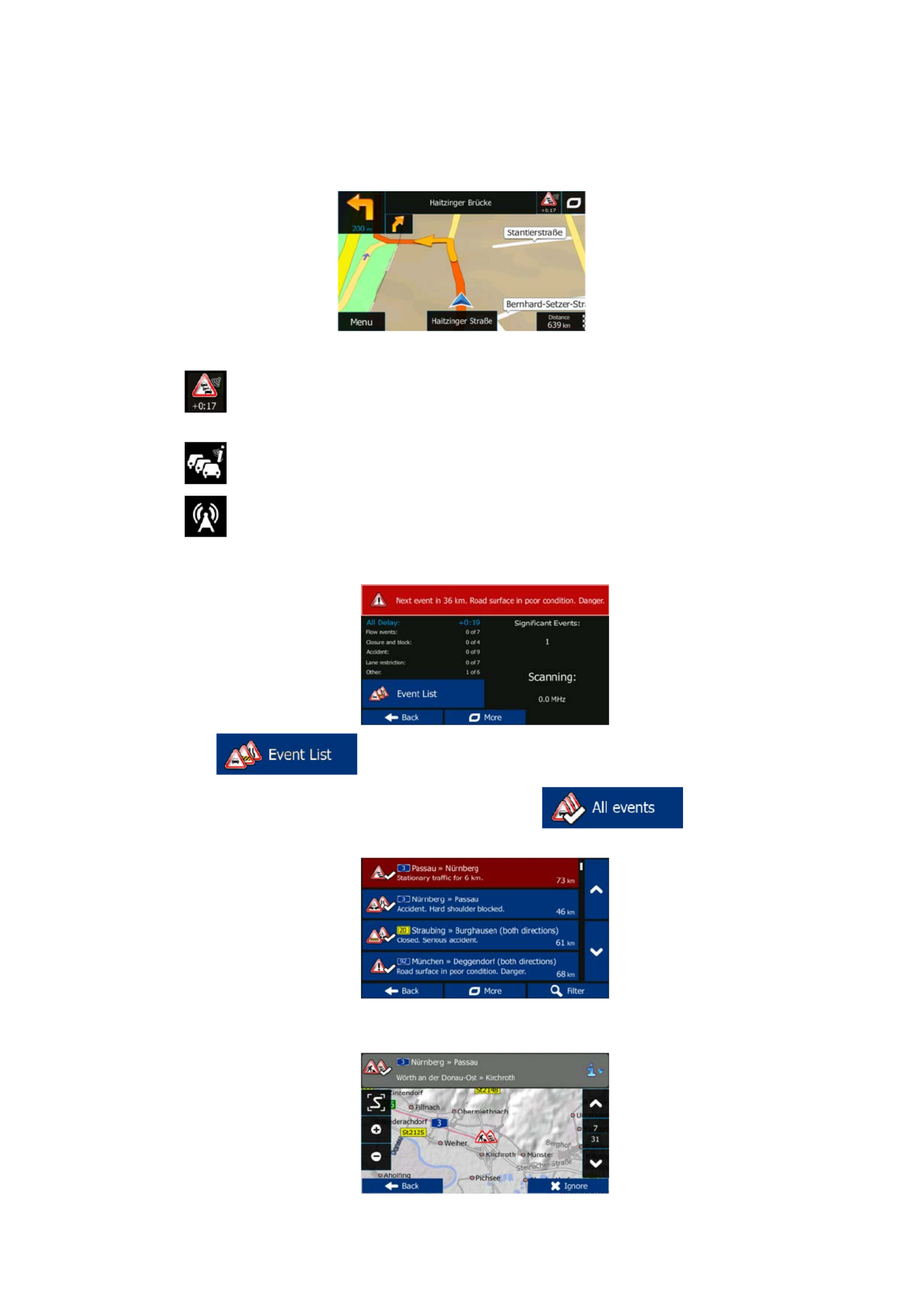
2.3.3.8 Traffic events
Road segments affected by traffic events are displayed with an alternate colour on the map,
and small symbols above the road show the nature of the event:
One of the following icons is displayed on the right side of the screen:
• When there is an event on your route, the icon shows the type of the next traffic
event.
• Traffic information is received, but there are no events affecting your route.
• Traffic information is not received.
1. Tap any of the above icons to open the Traffic Summary screen.
2. Tap to open the list of event categories.
3. Tap the traffic category you are interested in, or tap to see the list
of all events:
4. Now tap any of the list items to see its details, and to display the affected road
segment in its full length on the map:
Termékspecifikációk
| Márka: | Blaupunkt |
| Kategória: | Navigator |
| Modell: | 73 |
Szüksége van segítségre?
Ha segítségre van szüksége Blaupunkt 73, tegyen fel kérdést alább, és más felhasználók válaszolnak Önnek
Útmutatók Navigator Blaupunkt

21 Március 2025
29 Szeptember 2024
19 Szeptember 2024
9 Szeptember 2024
1 Szeptember 2024
24 Augusztus 2024
11 Augusztus 2024
11 Augusztus 2024
11 Augusztus 2024
7 Augusztus 2024
Útmutatók Navigator
- Navigator Sony
- Navigator Acer
- Navigator Grundig
- Navigator Philips
- Navigator Pioneer
- Navigator Kia
- Navigator SilverCrest
- Navigator Garmin
- Navigator JVC
- Navigator Harman Kardon
- Navigator Nokia
- Navigator Toyota
- Navigator Medion
- Navigator Motorola
- Navigator VDO
- Navigator Zebra
- Navigator Insignia
- Navigator Boss
- Navigator Mazda
- Navigator Chrysler
- Navigator Volkswagen
- Navigator Polaroid
- Navigator Skoda
- Navigator Kenwood
- Navigator Audi
- Navigator V7
- Navigator Asus
- Navigator Navitel
- Navigator Raymarine
- Navigator Lowrance
- Navigator Hitachi
- Navigator Alpine
- Navigator Alfa Romeo
- Navigator Parrot
- Navigator Cobra
- Navigator Scosche
- Navigator ModeCom
- Navigator Sygic
- Navigator Overmax
- Navigator MaxCom
- Navigator Clarion
- Navigator Humminbird
- Navigator Mio
- Navigator Conrad
- Navigator TomTom
- Navigator Jensen
- Navigator Pyle
- Navigator Sanyo
- Navigator Lenco
- Navigator Uniden
- Navigator Zenec
- Navigator GoClever
- Navigator Dual
- Navigator Airis
- Navigator Caliber
- Navigator Bushnell
- Navigator Sylvania
- Navigator Marquant
- Navigator Celestron
- Navigator Binatone
- Navigator Magellan
- Navigator Audiovox
- Navigator Navigon
- Navigator Eagle
- Navigator Autovision
- Navigator Navman
- Navigator Wahoo Fitness
- Navigator Lanzar
- Navigator Simrad
- Navigator Furuno
- Navigator Teasi
- Navigator Kapsys
- Navigator Coyote Systems
- Navigator Danew
- Navigator Rand McNally
- Navigator GolfBuddy
- Navigator Soundstream
- Navigator VDO Dayton
- Navigator Becker
- Navigator Igo
- Navigator Kalkhoff
- Navigator Route 66
- Navigator Falk
- Navigator Seecode
- Navigator Nav N Go
- Navigator Pharos
- Navigator Viamichelin
- Navigator Xzent
- Navigator CarTrek
- Navigator Whistler
- Navigator Dynavin
- Navigator Cheetah
- Navigator Cydle
- Navigator ESX
- Navigator Lark
- Navigator LXNAV
- Navigator Planet Audio
- Navigator Eclipse
- Navigator Voice Caddie
- Navigator SkyCaddie
- Navigator TELE System
- Navigator IZZO Golf
- Navigator Zoleo
- Navigator Dashmate
- Navigator GlobalSat
Legújabb útmutatók Navigator

31 Március 2025

12 Január 2025
1 Január 2025

31 December 2025
30 December 2025
30 December 2025
22 December 2024
14 December 2024
14 December 2024
14 December 2024